Thanks Solaris that was very helpful.
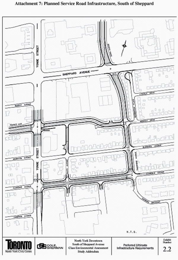
I chuckle a little bit when I see that diagram. I'm sure the planner who designed it wished the real world acted a bit more like SimCity and they could just bulldoze the whole area and start fresh.
Starting from Sheppard Ave & the redesigned Tradewind Ave intersection.. you basically have to get rid of everything slightly to the west of Bonnigton Place. Mainly just old homes, but on the corner at Sheppard there are little businesses running out of the homes (accountants & lawyers I believe).
Then you still have Bonnington Place running parrallel to the new extension of Tradewind. Not sure you can squish much in there housing wise so I guess it becomes a grass strip (similar to what they've done further north on Dorris).
This all feeds down to Avondale which is already nuts during the rush hours (getting longer each day it seems). Since this is part of the ring road, I guess its aim is to alleviate pressure from Yonge. This may solve some of the northbound traffic problems but it's not going to do anything to fix the southbound problems. Southbound most of the traffic is trying to get to the 401. It's pretty much concentrating the choke point to the Avondale/Yonge intersection.
Back to Anndale Dr.. the distance between the townhouses of Spring and the Cosmo buildings will make things a little tight for that stretch of the road. Coming out at Yonge St expanding the intersection makes sense but I'm not quite sure how they will handle the east side where you will have east/west lanes for the P&G building and Anndale drive in the same set of traffic lights. And of course all of that is dependent on the Tridel Hullmark Centre actually getting built at some point.
That's a lot of changes for a very small area

