


Transportfan
Senior Member
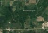
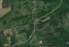
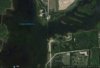
Hurontario Street runs from Mississauga north to Collingwood. The southernmost and northernmost stretches followed (and still follow in part) Highway 10 and former Highway 24 respectively. The middle section, from Orangeville to Glen Huron, is bypassed, though it still exists, broken into sections, with the split from Hwy. 10 occurring at Highway 9. The first bypassed section is visible near the centre of this Google satellite image, south and east of the Orangeville Reservoir, partially in the Island Lake Conservation Area:

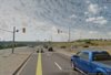
This Street View grab looking north shows the location where Hurontario and Hwy. 10 part company at Hwy 9, with 10 continuing on north alone. The former course of Hurontario (and until the 1960s, until a bypass was constructed, 10 as well) can be seen bearing off to the right, and is now vacant land, still marked with the hydro poles that lined it. The original Hurontario actually continued south of this point, running about 100 feet to the right of the blue pickup before merging with the baseline:

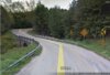
Looking south from the first stub of the bypassed Hurontario, robbed of its role as an important thoroughfare, here only provides access to a hotel:

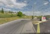
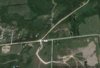
Looking north, across Buena Vista Drive; Hurontario St. bends slightly right to follow a strict north-south alignment at the concession road survey boundary. Buena Vista Dr. was the former route of Hwy. 9. Before the Hwy. 10 bypass was built (visible on the left), 10 turned left here to run concurrently with Hwy. 9 into downtown Orangeville via Broadway before turning north again. Given this was a significant historic crossroads, dating back to the pre-highway era, one may wonder why this minor intersection isn't Orangeville's "four corners":

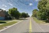
North of Buena Vista, Hurontario is a quiet residential street:

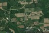
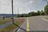
Further north, Hurontario St. is broken by the manmade Orangeville Reservoir. Part of it was drowned by the reservoir but the submerged portion is still clearly visible:

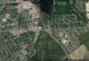
Beyond the reservoir in the Town of Mono, Hurontario is broken yet again between 5th Sideroad and Hockley Road:

Very rustic:

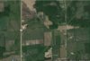
Still in Mono, the now clearly-distinct parallel roadways of Hurontario St. and Hwy. 10:

This Street View grab looking north shows the location where Hurontario and Hwy. 10 part company at Hwy 9, with 10 continuing on north alone. The former course of Hurontario (and until the 1960s, until a bypass was constructed, 10 as well) can be seen bearing off to the right, and is now vacant land, still marked with the hydro poles that lined it. The original Hurontario actually continued south of this point, running about 100 feet to the right of the blue pickup before merging with the baseline:
Looking south from the first stub of the bypassed Hurontario, robbed of its role as an important thoroughfare, here only provides access to a hotel:
Looking north, across Buena Vista Drive; Hurontario St. bends slightly right to follow a strict north-south alignment at the concession road survey boundary. Buena Vista Dr. was the former route of Hwy. 9. Before the Hwy. 10 bypass was built (visible on the left), 10 turned left here to run concurrently with Hwy. 9 into downtown Orangeville via Broadway before turning north again. Given this was a significant historic crossroads, dating back to the pre-highway era, one may wonder why this minor intersection isn't Orangeville's "four corners":
North of Buena Vista, Hurontario is a quiet residential street:
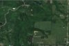
Further north, Hurontario St. is broken by the manmade Orangeville Reservoir. Part of it was drowned by the reservoir but the submerged portion is still clearly visible:
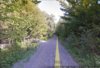
Beyond the reservoir in the Town of Mono, Hurontario is broken yet again between 5th Sideroad and Hockley Road:
Very rustic:
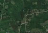
Still in Mono, the now clearly-distinct parallel roadways of Hurontario St. and Hwy. 10:
Attachments
Last edited: