News   Mar 28, 2024
 187     0 
News   Mar 27, 2024
 2K     1 
News   Mar 27, 2024
 1.2K     2 

Humberline bridge...?

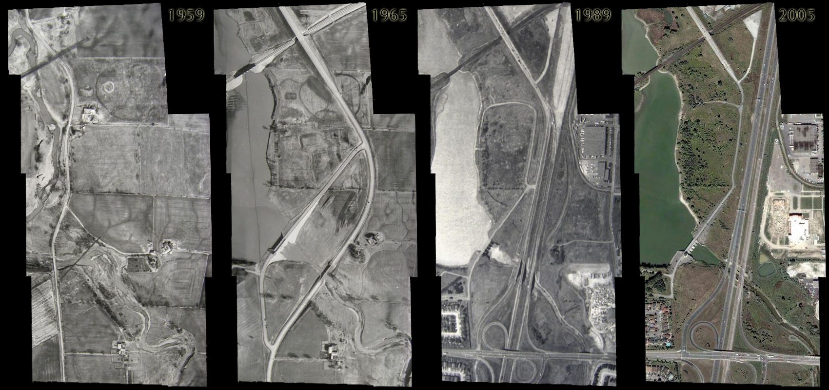
Lack of photographic evidence certainly does not mean there was no bridge.

No, but when it doesn't show up in pre-Hazel aerial shots, the idea it was destroyed by the hurricane and never replaced is put to bed. I've found old maps to be wholly unreliable. They predict roads that were never built and lay them out as though they existed, they play fast and loose with the actual course of any road that isn't a straight line, and they famously propose bridges that were simply on county wish-lists. I have a map of Toronto from 1955 that insists a bridge connects Woodvine Ave. to Woodbine Heights. I've been there to check it out and the idea is plainly absurd; even now it would be an engineering headache, and a useless one since Woodbine Heights leads nowhere beyond.

The same is true for Humberline. It was close enough to Hwy 27 that, while York County might have intended to bridge it eventually, there simply wasn't the pressing need to, and I don't imagine it ever got off the back-burner, unless the local farmers did it. If so, no doubt the Humber flooded anything ad hoc away enough that they eventually would have just given up. But I know all kinds of obvious places for bridges that never were, or weren't until the need and money met in the middle. Steeles itself didn't even cross the Humber till 1983 (though I've seen older maps that insist it did -- again, wishing in advance of doing), so it's hardly remarkable that a road like Humberline never did. In Mississauga, Eglinton didn't cross the Credit till the end of the 1960s, and Burhamthorpe until 1973, I believe. Sheppard still doesn't cross the Humber, though a direct conncection to Rexdale would be of real use (not infrequently to me). There's never been a bridge completing Post Road, either, though again I've seen maps that suggest one was there.

I don't know if it's your bailey bridge, but the point is, when a bridge exists (esp. predating Hazel) in Toronto, there's always photographic evidence of it, if only from above. Re: Indian Line...

470872475_dd512a5ff7_o.jpg


And as I've said, in the 1953 aerial image of the region, there's no bridge at Humberline over the river. This was a pet project of mine, too, before I ever saw it mentioned here. If there was every anything there, there's no hint of it now, and it was never anything substantial.
 
Thanks Lone Primate for the photos. Yes, clearly there was no bridge in the recent past, but I still wonder a bit about farther back, before we have any aerial images.
On another note, it is the Bailey Bridge in the 1965 aerial photo - I am still looking for any archive photos of it from the ground....
 
I don't know if there were ever an older bridge there... the city's aerial shots go back to 1947, and they've withdrawn the 1947 shots from general public access. I imagine it's possible there was something there but there doesn't seem to be anything to substantiate it but unreliable maps. Unless someone made some kind of note about it in some York County record or something, we might never know.

I found it intriguing that you were familiar with Indian Line and the bridge there; that must have been quite a while ago. I remember being on the 427 when it sort of "started" at Finch and there was still that odd signaled intersection at Morningstar, but I don't know if I ever made it up that big bridge over the tracks, and I'm certain I wsa never there when Indian Line was still a going concern and had that bridge over the Humber. That must have been something to see.
 
OK, trying to dig into my aging memory banks to recall my experiences in this area.
I lived in the Clarkson/Lorne Park area of Mississauga from 1976 to 1980 and then Rexdale from 1984 to 1990 so most of my experience in the 'Claireville' area is from then. I recall when the 427 only went north of the 401 up to Pearson Airport (Malton Airport back then) - in the mid 1970's. That was when the Constellation Hotel was a going concern and not the next "Bayview Ghost". I actually attended the first Toronto Star Trek convention there in 1976.

They extended the 427 - first widening to Rexdale Blvd/Derry Road, where it then turned back into a narrower Indian Line as it headed north. Morningstar Drive was an intersection to the west only with no traffic control. Finch did not exist just east of Indian Line and just past there the road curved to the east and went down toward the Humber River, where a single lane Bailey Bridge crossed the Humber, controlled by Traffic Lights. I loved driving up that way, it was peaceful the way you left the city and within a minute were in the country.

The Claireville Dam was there of course, having been built in the wake of Hurricane Hazel that struck Toronto in October 1954. That was when the Toronto Conservation Authority built many flood control projects and other Bailey Bridges were built to replace bridges washed out by the Hurricane.

I actually worked at 93 Claireville Drive for a time, which is the building just north of the new Mosque that is north of Finch. The mosque was built right where an old house used to be which you can see in the aerial photos.

You can actually still see a remnant of the old Indian Line just before it would have crossed the Humber at the 427/Finch exit - as a wide flat path of grass visible when you travel South on 427 just to the left of the exit to Finch Avenue.

They continued to widen the 427 up to Finch Avenue and put in the Finch bridge and extension. Initially they left Morningstar Drive open with a stop sign in the middle of the 427 as you turned left heading north. They planned to close off Morningstar, but my understanding at the time was that due to a lot of taxi drivers who lived in the area, they left it open to allow easier access for them. (I'm not sure how true that is but that is what we were told.)

They put traffic lights there as it was becoming very dangerous to cross the 427 to get onto Morningstar. At some point when they built the 409, many of you may recall that there was no ramp from southbound 427 to eastbound 409, but traffic lights there to turn left across northbound 427 then down a ramp to the 409.

For a short period of time during this construction there was also an access road that believe it or not ran off the southbound 427 just south of the railway tracks that went steeply down the embankment to Goreway Drive, just opposite was is now called Zahavy Way. It was a pretty awesome shortcut and very steep. It did not last long.

I also remember when Albion Road ran it's original course west of the now 427 through the village of Claireville. There was a guy there who sold hubcaps and he had pretty much everything.

The interesection of Albion, Steeles, Indian Line and Hwy 50 was one of the coolest ever. I also used to take the section of Gore Road between Hwy 50 and Hwy 7 (Queen Street) as a short cut and recall a scary water filled quarry there which seems to be gone now.

Wow - memories!!!
 
I actually worked at 93 Claireville Drive for a time, which is the building just north of the new Mosque that is north of Finch. The mosque was built right where an old house used to be which you can see in the aerial photos. You can actually still see a remnant of the old Indian Line just before it would have crossed the Humber at the 427/Finch exit - as a wide flat path of grass visible when you travel South on 427 just to the left of the exit to Finch Avenue.

I was a relative latecomer to this, but there early enough that I might have paid it some kind of mind. It just wasn't where my head was at at the time. I wish to God I'd been more attuned to this kind of thing back when there was still something to see.

They continued to widen the 427 up to Finch Avenue and put in the Finch bridge and extension. Initially they left Morningstar Drive open with a stop sign in the middle of the 427 as you turned left heading north. They planned to close off Morningstar, but my understanding at the time was that due to a lot of taxi drivers who lived in the area, they left it open to allow easier access for them. (I'm not sure how true that is but that is what we were told.) They put traffic lights there as it was becoming very dangerous to cross the 427 to get onto Morningstar. At some point when they built the 409, many of you may recall that there was no ramp from southbound 427 to eastbound 409, but traffic lights there to turn left across northbound 427 then down a ramp to the 409.

I don't remember a stop sign in the middle of the 427 but I can and do remember the weird stoplight on the southbound lanes. I had a friend who was renting a place in Malton around 1990 and I can recall sitting in the middle of the highway, waiting for that light. At the time, the 427 (as such) only started up at Finch, and it was fun watching 18-wheelers that had just barreled down the onramp having to stop dead in the middle of a 400-series highway less than a mile later. I've always wondered how many people cashed in their chips at that intersection. Must have been some because that "convenience" only lasted a few years. I'm not sure I ever got any further north than that.. it's possible I did, riding shotgun, but I honestly can't say I remember crossing that really impressive bridge they built over the railroad tracks. Seems strange they would build something capable of carrying four lanes and then just abandon it. I've often wondered if the 427 weren't originally intended to follow that course.

I don't personally remember the light for the 409 but I heard about it and I went looking for aerial shots of it and finally found them. That must have been a real doozy too.

For a short period of time during this construction there was also an access road that believe it or not ran off the southbound 427 just south of the railway tracks that went steeply down the embankment to Goreway Drive, just opposite was is now called Zahavy Way. It was a pretty awesome shortcut and very steep. It did not last long.

That's one I actually discovered in the aerial shots of the 427 under construction in the 1970s. It was a weird arrangement that bears little resemblance to what exists today; a whole lot of ad hoc connections that struck me as really practical, and some of them would still be useful today.

Wow, sure wish I could have seen it in the day. Don't suppose you took any pictures back then, did you? :)
 
Wish I had taken photos. Back then it was taken for granted that things were the way they were, and I guess we did not think about progress :) Today I sometimes feel goofy taking pictures of everyday streets and stuff, but think about how things change and that it might be nice to have a record of how things were...
 
That is awesome! Memories of Mississauga as it looked when I lived there!

Ditto! That's right around the time I got my license. :)
 
More to the point, fellahs... here's that light at Morning Star Drive, and at least a mention of the light for southbound 427 to eastbound 409 access... enjoy!! :)

 
Meanwhile elsewhere on the Humber...

There was oil leaching into the Humber last night near the Old Mill. Supposedly a contractor who paved in the are (Old Mill Dr) left a lot of paving material in the culverts and the rain yesterday saw all the oil leach out into the storm sewers.

The City had to get a crew in to work overnight to get all the material out of the storm sewers. All fixed but not without a lot of chemicals floating down the river. I hope the MOE is informed and the asphalt crew is banned from city work (but good luck on the later)

(btw...if you are in Etienne Brule park you can still smell it where the culvert joins the Humber just North of Catherine St (a.k.a Old Mill Rd when you get into Etobicoke)
 

Back
Top