News   Mar 28, 2024
 982     2 
News   Mar 28, 2024
 553     2 
News   Mar 28, 2024
 846     0 

High Park

It’s Time for a Safer Parkside

From link.

Since the Toronto Community Bikeways Coalition was formed last May, one of their primary asks has been to put in a bikeway along Weston Road and Keele Street from Cardell Avenue to Bloor Street. However, Keele continues onto Parkside Drive from Bloor to Lake Shore Boulevard which is a fast moving arterial and unpleaseant for those who walk or bike. Earlier this month, the Sunnyside Community Association held a Zoom meeting in which many of the more than 40 people in attendance were supportive of safety improvements on Parkside including bike lanes. A separate Facebook group called “Safe Parkside” was also organized around this issue.
In its current form, Parkside Drive is a 12.8 metre wide major arterial with four traffic lanes and a 50 km/h speed limit. However, observed speeds are much faster with 70 km/h not being uncommon and the road serves as a key access point for Lake Shore and the Gardiner Expressway. The east curb lane (northbound) is used for parking, but is not allowed from 4:00 to 6:00 PM from Monday to Friday. A sidewalk is available only on the east side which – at 1.5 metres wide – is too narrow for two people to comfortably pass each other; something even more problematic with COVID-19.
Parkside%2B-%2BExisting.png

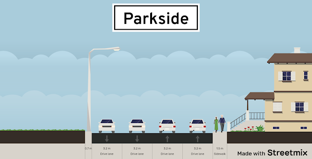
Existing layout of Parkside Drive
From a cycling standpoint, there are two problematic intersections. A multi-use trail immediately north of The Queensway crosses Parkside but does not have a pedestrian crossover. People walking or biking who wish not to jaywalk have to go 110 metres north to the traffic signal at Spring Road and come back down before continuing. To avoid having people bike on the sidewalk, a pedestrian crossover is urgently needed. If one can be put in at Roncesvalles and Westminster Avenues – only 100 metres north of the traffic signal at High Park Boulevard – there is no excuse not to put one in.

The other intersection lies at Lake Shore and Parkside. The pedestrian signal for crossing the eastbound lanes of Lake Shore takes forever to change and many people – myself included – cross it illegally to get to and from the Martin Goodman Trail. The four slip lanes and complex signalling also encourage unnecessarily fast motor vehicle traffic and excessive land use. I would recommend two actions here. The slip lanes need to be replaced with a T intersection in the short term, while a longer term solution would involve moving the eastbound Lake Shore lanes north so they are adjacent to the westbound ones. The parking lot for Palais Royale and Sunnyside Beach would need to be realigned as well which would help expand available park land, while the ramp from the Roncesvalles pedestrian bridge to the Palais Royale parking lot would need to be removed for this to work.
Lake%2BShore%2Band%2BParkside%2B-%2BReimagined.jpg

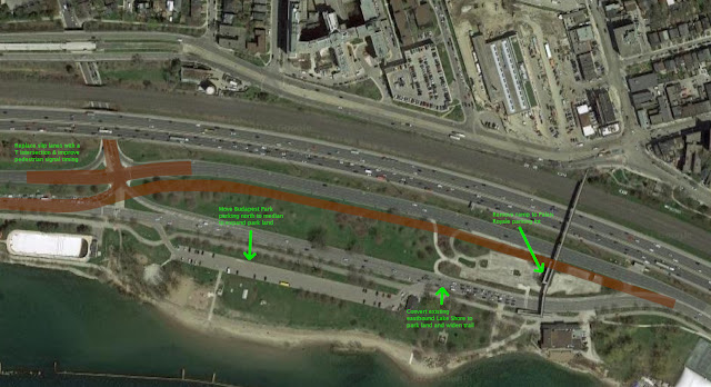
A reimagining of Lake Shore at Parkside including the realignment of the intersection and eastbound lanes (in brown) to allow for expanded park land
Per a post from Tyrenny Anderson – one of the group admins – there are three requests the group has put together.
  1. Allow cars to remain parked between 4:00 and 6:00 PM to create a protective physical barrier between cars and pedestrians.
  2. Enforce the speed limit and honour the community safety zone designation for all cars traveling on Parkside Drive.
  3. Review the design of Parkside Drive to ensure it meets safety requirements. Commit to upgrades that will make the street safer and better to use for pedestrians and cyclists.
Given there are limited crossings on the west side of Parkside, the ideal solution would be to replace the southbound curb lane with a multi-use trail, while the eastbound curb lane would be converted and narrowed into a 24-hour parking zone with the extra width used to widen the sidewalk. Two traffic lanes would be maintained while the speed limit should be reduced to 40 km/h as has been done on other major arterials within Toronto – East York.
Parkside%2B-%2BProposed.png

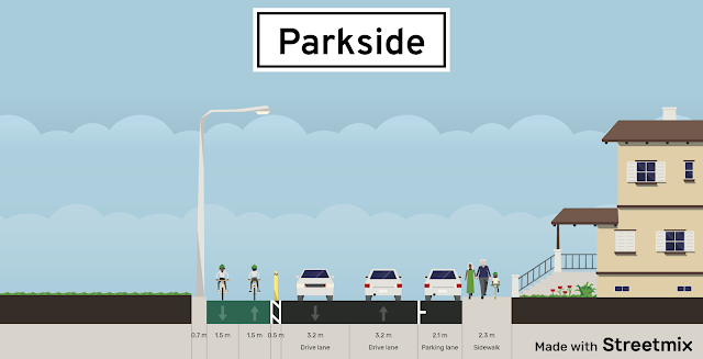
A proposed layout for Parkside including a multi-use trail and a wider sidewalk
The fact many residents in Sunnyside and Roncesvalles support a safer Parkside provides justification to include Parkside as part of a bikeway along Keele and Weston for an eleven kilometre continuous north-south route from the Waterfront to just before Highway 401. Having biked by Weston on Saturday to get my COVID-19 vaccine – which I encourage you to do as soon as possible if you haven’t yet – I can confirm the need for a bikeway there to give Weston and Mount Dennis residents safe transportation options. Especially with those neighbourhoods having higher than average COVID-19 cases and the 41 Keele and 35 Jane bus routes being among the busiest during the pandemic.
 
Some small scaled infill along this block. It is currently the property in the middle here, between the Dentistry place and Dry Cleaners.

Located along Dundas West, a couple blocks north of Bloor West, and across from the shopping plaza with FreshCo and Shoppers:

I'll just put this here as West Bend tends to get grouped into "High Park North". And on its own the area isn't quite eventful enough to be separated into another neighbourhood thread.


2413 DUNDAS ST W
Ward 4: Parkdale-High Park

Proposal to construct a 3-storey rear addition containing 4 dwelling units to the existing 3-storey building.


dunwest.JPG
 
Last edited:
Some small scaled infill along this block. It is currently the property in the middle here, between the Dentistry place and Dry Cleaners.

Located along Dundas West, a couple blocks north of Bloor West, and across from the shopping plaza with FreshCo and Shoppers:

I'll just put this here as West Bend tends to get grouped into "High Park North". And on its own the area isn't quite eventful enough to be separated into another neighbourhood thread.


2413 DUNDAS ST W
Ward 4: Parkdale-High Park

Proposal to construct a 3-storey rear addition containing 4 dwelling units to the existing 3-storey building.
merseyside.png


Looks like that's back here behind the Merseyside Cafe. Family members would like to live there so they can get their scones without going outside! :)
 
I expect those would be the main entrances to the residential units, unless they reconfigure the front to allow access through the cafe.
Oh, I'm wrong. They're making an entrance to all of the back units via the walkway on the north side of the building that will provide access to a lobby and stairs (details in the plans doc).
 
A few taken today, April 10th, 2022; all from the path next to Queensway.

First, Grenadier Pond:

DSC07194.JPG


DSC07195.JPG


DSC07196.JPG


Then two taken of a denizen of the small marshlands closer to Parkside:

DSC07197.JPG


DSC07198.JPG


Above is a Wood Duck, the male to be precise, his mate stayed a bit more hidden from view......
 

Toronto wants to reduce car-free weekends in High Park

From link.

The debate about a car-free environment in High Park continues to rage, but it appears as though a reduction in car-free days is on the horizon.

According to the High Park Movement Strategy, which claims to respond "to diverse mobility needs of different user groups," and takes action to "better serve park users," the city prefers to implement permanent, car-free spaces on West Road and Colborne Lodge Drive and car-free Sundays.

The catch? High Park currently operates with car-free weekends, meaning the city would want to reduce this for an entire day.

The city claims these two suggested moves, alongside many others, will bring "improvements to pedestrian and cycling safety and infrastructure" and will greatly reduce the number of cars in the park.

Launched back in 2021, the initiative has been through a "multi-phase engagement process" and the city has heard from thousands of participants — though I doubt cyclists and non-drivers would want to see a reduction in car-free weekends.

The strategy will be presented tonight at a community open house, where the suggestions would be backed up by "improvements to transit and shuttle service, traffic calming measures and changes to parking."

"Further road closures within High Park were strongly supported through the study's engagement and can be upheld as a viable, desirable goal once pre-conditions such as improved transit and shuttle services are in place," said the city.

Because of the park's layout and amenities, the city claims "some accommodation for motorized transport is necessary at this stage in order to meet accessibility and operational needs."

This preferred strategy is just one step in helping the city submit a final recommendation and staff report this spring. A timeline for this potential implementation will be based on city council input.

Though the strategy has been planned out by the city, it does not mean it will go forward in its current state; it can also be amended by council vwhen it goes for approval.

When I asked the city directly if they prefer to implement car-free Sundays rather than car-free weekends, they responded with: "the preferred strategy includes the permanent closure of two park roads to visitor vehicles (West Road and portions of Colborne Lodge Drive) and the continuation of car-free Sundays."
1680555591540.png

1680555624634.png

1680555651360.png

1680555700843.png

1680555744295.png


1680555765545.png


1680555789803.png

1680555811135.png

1680555848329.png

1680555872370.png
 
Need more parking for High Park?

4.5 ha of marshland at the south end of Grenadier Pond was given to Metro Transportation when the Queensway extension was built in the early 1950’s.
preview
From link.

The Queensway was built as a wide 3 lanes in each direction want-to-be-expressway stroad. The lanes were w-i-d-e. And fast, with 40 mph/60km/h speeds.
photo-toronto-queensway-looking-e-st-joseph-hospital-high-park-on-left-esso-sign-1967.jpg

From link.

And no parking allowed on The Queensway. Today they created cycling lanes, and still no parking stopping.
1680641426158.png


Move the cycling lanes off the roadway and create dual-direction cycling paths west of the Parkside Drive overpass. Keep the cycling lanes on the overpass, for cyclists to be able to get over Parkside Drive. Narrow the lanes to accommodate a 50 km/h speed and create parking slots on The Queensway. With bumpouts at the corners to slow down right turns. Same parking fees as inside the park.

corner-bumpout-diagram.jpg

From link.
 
Last edited:

Back
Top