News   May 02, 2024
 1K     2 
News   May 02, 2024
 495     0 
News   May 02, 2024
 364     0 

Dufferin Street railway bridge repairs/closure (City of Toronto, near CNE)

My dream is for the chain link fences to come down and install a nice wide sidewalk with enough room for benches or a hot dog stand with connections to the path at the top of the hill with steps and ramps. This stretch could be like Central Park West (the street) in New York.

Complete Streets > fast roads and footpaths
 
Imagine you live in Parkdale or Liberty Village and want to walk down to the water while pushing a baby stroller. There are basically zero good options. West of Strachan, there is not a SINGLE road that goes directly to the waterfront until Parkside. A level crossing at a Dufferin and Lakeshore intersection would be the most preferable way to get to the water for a huge number of local residents.
It's been about 5 years since I've pushed a stroller through there - but there were plenty of ways to do it then. Normally I just walked straight from Exhibition Stadium due south. Or use the path near Dufferin.

When did they remove all these options? And why would you need roads to do this?
 
It's been about 5 years since I've pushed a stroller through there - but there were plenty of ways to do it then. Normally I just walked straight from Exhibition Stadium due south. Or use the path near Dufferin.

When did they remove all these options? And why would you need roads to do this?

It's not that it's IMPOSSIBLE, it's that it's not simple. Dufferin is the only level entry into ExPlace. What could be simpler than a straight line!
It's about psychological ease as well. Being able to say to yourself "I can just walk all the way down Dufferin" makes it more accessible in my mind.
You could also run the Dufferin bus all the way down to the water instead of terminating at the gate.
It would also be a more accessible entry point INTO ExPlace from the south, if you're already down on the waterfront.
I think drivers would appreciate it as well! Being able to turn up Dufferin from Lakeshore might be preferable for people trying to get to Parkdale or Liberty village, depending on where they're coming from.

Big picture, to better integrate ExPlace and Ontario Place into the city and make them more accessible you need more and simpler access points. It's the same principle that has been applied to Regent Park and Alexandra Park public housing redevelopments: integrate it all into the existing grid!
 
From link.

Waterfront Transit Network – Exhibition Loop-Dufferin Gate Loop Streetcar Extension​

The Exhibition Loop-Dufferin Gate Loop Streetcar Extension project is part of the Council-approved Waterfront Transit network plan. The project would build a new streetcar connection between Exhibition Loop, on the north side of Exhibition Place, and Dufferin Gate Loop on Dufferin Street north of the Dufferin Gate of Exhibition Place. This would connect waterfront streetcar service to the west end of the network, providing new service options.
This new track segment would also be designed to connect to a future westward Humber Bay Link, which would provide a more-direct streetcar service to the western waterfront, the Park Lawn area, and Lake Shore Boulevard West. The project is coordinated with the City’s construction of a new Dufferin Street bridge over the railway and the Gardiner Expressway, and space is reserved on that new bridge for the future streetcar track. Design work on this project was completed to 30% design in early 2020, and was then put on hold pending a full understanding of the design, ridership, and pedestrian movement effects of the Province’s Ontario Line project and its station at Exhibition Place. With the advancement of Ontario Line plans, it is expected that design work can be resumed on this project in 2022, and a separate report to the Board would be prepared at that time.
 
It's not that it's IMPOSSIBLE, it's that it's not simple. Dufferin is the only level entry into ExPlace. What could be simpler than a straight line!
There's the entrance off Strachan - though not great from Parkdale.

But what's wrong with the entrance off Atlantic? There's stairs, so it's not level. But there are elevators at each end.
1631199547472.png


It's about psychological ease as well. Being able to say to yourself "I can just walk all the way down Dufferin" makes it more accessible in my mind.
I'm missing something - there's a pathway from Dufferin Street, just about due south, to the bridge over Lakeshore. What's the issue with this?
1631199197013.png

You could also run the Dufferin bus all the way down to the water instead of terminating at the gate.housing redevelopments: integrate it all into the existing grid! It would also be a more accessible entry point INTO ExPlace from the south, if you're already down on the waterfront.
The 29C branch Dufferin bus runs past Dufferin Gate, and through Exhibition place, except for when there's a big event blocking traffic. And it's not infrequent! It's every 7 minutes through Exhibition Place all day, and every 10 minutes after 10 pm. It's even more frequent on Saturday/Sundays!
1631200007948.png

Big picture, to better integrate ExPlace and Ontario Place into the city and make them more accessible you need more and simpler access points. It's the same principle that has been applied to Regent Park and Alexandra Park public housing redevelopments: integrate it all into the existing grid!
Even more would be useful. Hence the plans to build another tunnel under the tracks at Jefferson.
1631200472120.png


And to add an overpass to the tunnel at Atlantic to reduce congestion at the new subway station.
1631200304540.png
 
All that stuff is great! As someone who lives nearby and had used the space a lot, I just think that extending Dufferin all the way down and creating a new intersection at Lakeshore would be a good idea too.
 
Isn't British Columbia Road itself a continuation of Dufferin Street? It already has an intersection with Lake Shore Blvd. W.. If one goes south on Dufferin Street in the Exhibition Place grounds, it curves west towards Lake Shore Blvd. along with an eastbound ramp onto the Gardiner Expressway from that intersection.

If they want to straighten Dufferin Street south to Lake Shore Blvd. W., they might as well get rid of the British Columbia Road intersection with Lake Shore Blvd. W.. Personally, I think they should leave the road as is. Extending the streetcar tracks south, east, and west is a completely different story.
 
There's the entrance off Strachan - though not great from Parkdale.

But what's wrong with the entrance off Atlantic? There's stairs, so it's not level. But there are elevators at each end.
View attachment 347520


I'm missing something - there's a pathway from Dufferin Street, just about due south, to the bridge over Lakeshore. What's the issue with this?
View attachment 347512


The 29C branch Dufferin bus runs past Dufferin Gate, and through Exhibition place, except for when there's a big event blocking traffic. And it's not infrequent! It's every 7 minutes through Exhibition Place all day, and every 10 minutes after 10 pm. It's even more frequent on Saturday/Sundays!
View attachment 347523


Even more would be useful. Hence the plans to build another tunnel under the tracks at Jefferson.
View attachment 347525


And to add an overpass to the tunnel at Atlantic to reduce congestion at the new subway station.
View attachment 347524

You're arguing that a single intermediate route, or possibly two, is reasonable (between Strachan and Dunn) over a distance of 1.75km.

Nowhere else in the City do we accept that a Blocks should average 875M; I'm not persuaded we should do so here either.

That there are routes that exist with varying degrees of difficulty and distance is not really, to my mind, an argument against more, closer, more direct choices.

No one is suggesting a subway every 400M, but a walking/bike route seems reasonable.

Dufferin is the easiest and most logical route to create.
In the spirit of better connecting Exhibition Place with Liberty Village, I think Metrolinx is missing a big opportunity with the Ontario Line. If they lowered the grade of all the tracks (and the new OL line) between Dufferin and Strachan (in the same manner the tracks to the north of Liberty Village were lowered to enable a grade separated crossing for Strachan) they could connect several streets under the Gardiner and re-connect these two segments of the city. Much, if not all the cost of this could be covered by allowing developers to build over these now lowered tracks (between the proposed new street along the south end of Liberty Village and the Gardiner)
 
In the spirit of better connecting Exhibition Place with Liberty Village, I think Metrolinx is missing a big opportunity with the Ontario Line. If they lowered the grade of all the tracks (and the new OL line) between Dufferin and Strachan (in the same manner the tracks to the north of Liberty Village were lowered to enable a grade separated crossing for Strachan) they could connect several streets under the Gardiner and re-connect these two segments of the city. Much, if not all the cost of this could be covered by allowing developers to build over these now lowered tracks (between the proposed new street along the south end of Liberty Village and the Gardiner)

While I'm sympathetic to the thought, I'm not sure what your suggesting would be feasible.

You're hemmed in by the new E-W road and its ROW in the north, and then by the Gardiner and the TTC Waterfront LRT ROW in the south, along with the platforms for the existing Exhibition GO not all that far to the west.
I get a free and clear distance of not more than about 25M for the rail corridor just east of Exhibition Place to around 33M off the foot of Pirandello St. Keeping in mind, that is building right to the City's lot line/edge of the Gardiner, that's very tight for any development, and I haven't allotted any space for retaining walls/tunnel walls which would obviously subtract some room there. In terms of development, you then have to subtract the space you would allocate to pushing Pirandello and maybe Hanna through to the south. East of Pirandello, you have 230M to Strachan. If you can live with the narrow profile, there's probably room for about 3 decent sized buildings, assuming you would want to break them up periodically for windows of sunlight from the south. West of Pirandello you have only 120M to the GO platforms. Assuming you buried/decked the platforms, you have about 370M to Hanna.
So in theory, 5 narrow profile buildings.

That may sound like a lot, but even at skyward heights, that would be an enormous cost to lower the rail corridor/deck over it for about 600M and change.
Lowering the corridor though has to be done gradually to create a very modest grade change, and it wouldn't be low enough if you assume the corridor had to meet its existing elevation at the margins of the 600M
You would have to shave off at least 2 buildings, maybe more to cover the 'shift' area.

All that and the absolute screaming you would get from all those Liberty Village condo owners whose Lake views you just erased.............

****

I would note, when you look northwards at the other rail corridor, that there is no building over it; and no streets crossing at-grade.

So simply replicating that idea is insufficient in scale/cost to allow for the through streets and buildings suggested.

IF the Gardiner were removed too, then we might have something to talk about; otherwise, I think we may have to abide the status quo, and/or lesser quality connections that far east.
 
Last edited:
While I'm sympathetic to thought, I'm not sure what your suggesting would be feasible.

You're hemmed in by the new E-W road and its ROW in the north, and then by the Gardiner and the TTC Waterfront LRT ROW in the south, along with the platforms for the existing Exhibition GO not all that far to the west.
I get a free and clear distance of not more than about 25M for the rail corridor just east of Exhibition Place to around 33M off the foot of Pirandello St. Keeping in mind, that is building right to the City's lot line/edge of the Gardiner, that's very tight for any development, and I haven't allotted any space for retaining walls/tunnel walls which would obviously subtract some room there. In terms of development, you then have to subtract the space you would allocate to pushing Pirandello and maybe Hanna through to the south. East of Pirandello, you have 230M to Strachan. If you can live with the narrow profile, there's probably room for about 3 decent sized buildings, assuming you would want to break them up periodically for windows of sunlight from the south. West of Pirandello you have only 120M to the GO platforms. Assuming you buried/decked the platforms, you have about 370M to Hanna.
So in theory, 5 narrow profile buildings.

That may sound like a lot, but even at skyward heights, that would be an enormous cost to lower the rail corridor/deck over it for about 600M and change.
Lowering the corridor though has to be done gradually to create a very modest grade change, and it wouldn't be low enough if you assume the corridor had to its existing elevation at the margins of the 600M
You would have to shave off at least 2 buildings, maybe more to cover the 'shift' area.

All that and the absolute screaming you would get from all those Liberty Village condo owners whose Lake views you just erased.............

****

I would note, when you look northwards at the other rail corridor, that there is no building over it; and no streets crossing at-grade.

So simply replicating that idea is insufficient in scale/cost to allow for the through streets and buildings suggested.

IF the Gardiner were removed too, then we might have something to talk about; otherwise, I think we may have to abide the status quo, and/or lesser quality connections that far east.
Thanks for the thoughtful response. I was thinking that you would eliminate the LRT tracks north of the Gardiner and have both east west tracks south of the Gardiner connecting to the Dufferin Loop and or continuing further west. Even applying the same treatment as the Strachan crossing would go a long way to connecting Liberty Village to the south and making the Ex more integrated into the city, rather than the island it is today. However, you are probably right, the cost would be tough to justify.
 
We can thank the Gardiner Expressway for the mess we're in.

The lost streets of South Parkdale

From link.

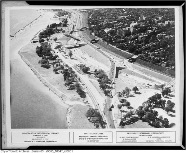
20170302-LostStreets-Aerial-600x494.jpg
South Parkdale during construction of the Gardiner Expressway in August, 1958

No Toronto neighbourhood paid for the Gardiner Expressway quite like Parkdale.

Before construction of the lakefront highway in 1958, the land south of Springhurst Avenue and the rail tracks was just like the rest of Parkdale: residential, consisting of mostly detached homes on spacious lots.

At the time, Dunn and Jameson Avenues passed over the rail tracks south to the waterfront and a tangle of smaller streets such as Laburnam and Starr Avenues, Empress Crescent, and Hawthorne Terrace intersected them.

South Parkdale was distinct enough to have its own railway station near the present-day foot of Close Avenue.

The first major road to penetrate the neighbourhood was Lake Shore Boulevard, which snaked south of Exhibition Place along the waterfront toward the Humber River in the 1920s.

In South Parkdale, Lake Shore Boulevard was created by merging and widening a number of residential streets, including Laburnam Avenue and parts of Starr Avenue.

There are subtle clues to the existence of these old streets. Lake Shore Boulevard subtly winds in the area north of Marilyn Bell Park, mirroring the former the routes of these lost streets.

The clearest example of this is where Lake Shore Boulevard turns sharply north to avoid the Toronto Sailing and Canoe Club near Dowling Avenue.
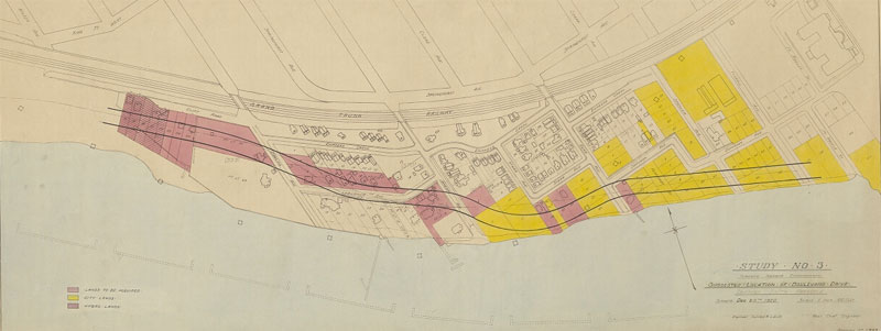
20170302-LostStreets-AreaMap-Alt.jpg
The planned path of Lake Shore Boulevard (then known as Boulevard Drive) through South Parkdale, December, 1920.

For the next few decades, South Parkdale remained relatively stable. Lake Shore Boulevard was five lanes wide and often busy with traffic, but houses and driveways still lined the route. The eventual destruction of the neighbourhood came in 1956, when construction began on the Lakeshore Expressway.

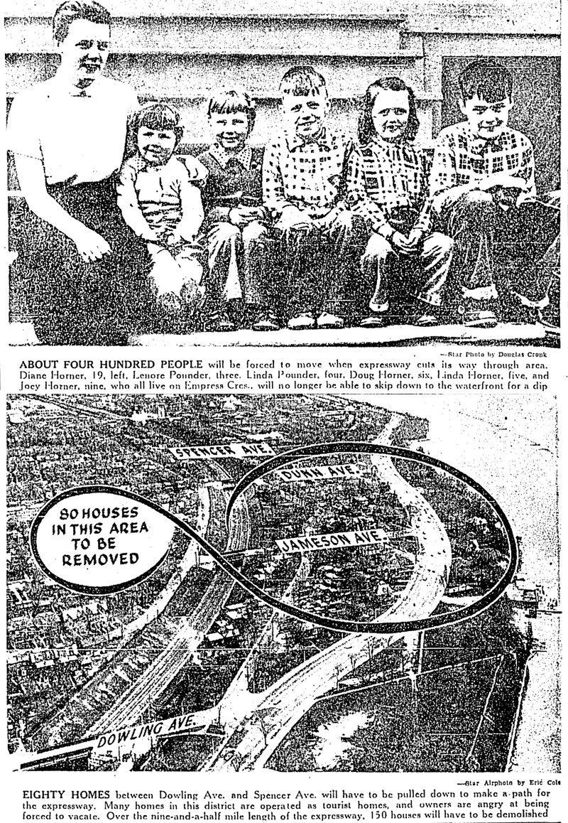
About 150 homes and 400 people were forced to make way for the expressway when the route was announced in 1954. For Dorothy Wood, who lived on the south end of Jameson Avenue, it was just history repeating itself. When she was young her parents’ home was expropriated for Lake Shore Boulevard.

“When they pulled down our house for Lake Shore Boulevard, we moved into this house,” she told the Toronto Star. “I like the location. It is cool in the summer—I don’t know where I could find another place like it in Toronto.”

Mrs. K. B. McKellar of Starr Avenue expressed similar feelings. “I love it here. I don’t want to move,” she said. “We have a very nice garden and a very pleasant view of the lakefront.”

Mr. C. L. Ellis, who operated a tourist property in the neighbourhood, took the news with a shrug. “If they hand us a big enough cheque for this property, we won’t kick too much,” he said. “But we’ve been here four years, we’ve put a lot of money into the place and we like the location.”

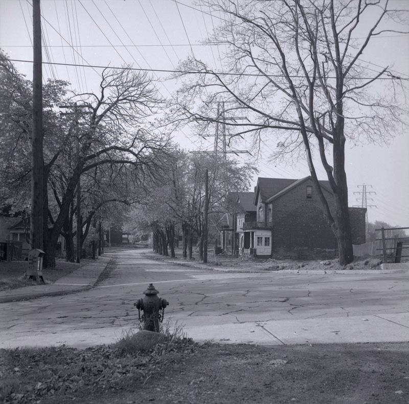
In 1956, photographer James Salmon pictured the condemned streets shortly before construction on the expressway began. The roads and sidewalks were empty and the yards overgrown and strewn with leaves. Within weeks, it was all gone.
20170302-LostStreets-Empress-Alt.jpg
Empress Avenue looking west from Dunn Avenue in 1956. Construction of the Lakeshore Expressway began the same year

To make a path for the Gardiner through South Parkdale, almost all the streets south of King and west of Dufferin were demolished. The houses on Starr Avenue, Laburnam Avenue, Empress Crescent, and others were all torn down and the trees, sewers, and fire hydrants removed.

Workers dug a trench for the new highway to the south of the rail corridor, creating a stark landscape that captured the imagination of a young novelist, playwright, and poet Milton Terrence Kelly.

“Parkdale was a construction site. All the Victorian homes, including the one next door to where my best friend lived, were being torn down for apartment houses,” he recalled.

“The great trench of the Gardiner went through, cutting us off from the Lake. While it was being built, we played there, pretending we were wolves; the ramp led up and fell off, as eerie and windswept as a desert.”
20170302-LostStreets-StarCombo.jpg

The area didn’t stay quiet for long. When the road opened in 1962, cars and trucks filled the highway and its access roads. Lake Shore Boulevard bloated to its current proportions, essentially acting as a second parallel expressway.

The former location of South Parkdale is now so dense with highways, feeder roads, overpasses, and traffic noise it’s difficult to imagine a time when it was anything like the rest of Parkdale.

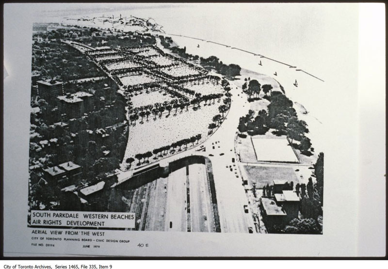
Toronto mayor John Sewell and Metropolitan Toronto chairman Paul Godfrey announced a plan with the potential to bring back South Parkdale in 1979.

At their direction, city planners studied the feasibility of covering over the Gardiner and rail corridor between Dowling Avenue and Exhibition Place, creating about 40 acres of new land for residential development.
20170302-LostStreets-Tunnel.jpg
Artists impression of the never-built expressway and highway deck that could have brought South Parkdale back to life.

Drawings from the resulting report showed mid-rise buildings on a restored South Parkdale street grid north of Lake Shore Boulevard.

“To encase the rails and road would indeed be grandiose,” wrote Globe and Mail columnist Dick Beddoes. “We’d have a mile-long covered corridor, which presumably, we’d call the Godfrey-Sewell Secret Passage. Or Tunnel Job.”

He clearly didn’t think much of the idea.

The tunnel plan was projected to cost somewhere in the region of $25-million, according to Parkdale councillor Barbara Adams, but nothing much came of it save for some paperwork.

South Parkdale will have to wait for its return.
 
Did @nfitz mean the building the temporary Dufferin bridge?

Yes I did. The temporary bridge was built very quickly in 2013, after the original bridge failed; after years of delays in the permanent replacement. One of which was the Strachan grade separation. They were then saying that they were going to put in a permanent replacement 8 or 9 years ago.

And now it's exactly same story again.

I've moved this to the thread we've been using for over 10 years, starting when the last time this happened.
 
So here's the thing UT; this is why @nfitz is a terrible person. LOL

He revives this thread, and pronounces that the City's site for this project has been updated, and he links it.......

So you know what that means........I had to click through........

Then I see something Nfitz didn't mention...........that the design for this had gone to the City's Design Review Panel in November '22; a quick toggle back, it never got posted here..........

So I had to go to the DRP's site, look up the meeting.................and well, here's what I found:

1690588280471.png


1690588314090.png


1690590429663.png


1690588424945.png


1690588480387.png


The link to the meeting is here:

Discussion of the Dufferin bridges begins at ~3:11

Assorted panel comments:

Panel was kind'ish, but generally were a bit underwhelmed; multiple members asked if the design/public realm could be more celebratory, a bit bolder, maybe some colour.

There were also a couple of comments on the narrowness of the sidewalk, which is pegged at 2.5m on both sides, the bike lanes 1.8m+ 0.8m buffer.

Also noted was the need for mitigation measures for 3 diff. crossing points of the LRT tracks by pedestrians/cyclists, and some question about whether the treatment of the 2 spans could be more harmonious. The glazing over the railway corridor was an Mx imposition.

My comments: Transportation should be directed to accept flowers and shrubs on bridges. I get not permitting trees..........the argument against flowers is that they can be thrown off the bridge; but people who want to be jerks can bring their own material to throw.....

The sidewalk capacity seems low, I agree, on questioning from the panel, the City staff admitted they hadn't yet modeled to see how much pedestrian capacity was actually required....... (insert eyeroll here)

I'd be interested in thoughts from UT's cyclists, but it strikes me that a multi-use path on the east side might be preferable to bike lanes here, it would be a more efficient use of space, but would also eliminate two interactions with tracks at Dufferin Loop.

Final thought, night-time illumination of the bridge and the arch should be a design consideration.
 
Last edited:

Back
Top