News   Jul 12, 2024
 1.1K     0 
News   Jul 12, 2024
 957     1 
News   Jul 12, 2024
 361     0 

"Downtown Core Line" - Possible Alignments?

What is your prefere alignment for a new E/W subway through Downtown


  • Total voters
    231
My only quibbles with your post is the suggestion that we build on Adelaid or Richmond to avoid the construction disruptions. As you point out, we build subways for a century or more. If that's the case, then why should we care about the impact of a a few years?

Because the more disruptive construction is allowed to be, the cheaper the construction costs and (because this will be financed entirely by debt) the better the long term viability. If we built along Queen or King, the TTC would be forced to adopt a lot of mitigation measures (i.e. rerouting streetcars, roads, not working at night, not storing much equipment on site ect..) which can have seriously raise prices. Given that Adelaide has little retail and residential uses, I would hope we could skip on some or most of these mitigation strategies.

My other quibble is the supposed unfeasibility of the rail corridor. For the life of me, I can't figure out why people keep saying that. Engineers have figured out ways to keep entire rail lines running while putting up bridges, or at-grade/above grade/below grade crossings, etc. I can't see why building under the rail corridor would be any more or less difficult that much of the work done on rail lines today, especially if they start work on the lines before they get 5 min GO REX service going

I'm sure it is feasible, I'm just not sure there will be any significant cost savings. Putting a tunnel box under a rail corridor can't really be that different from putting one under Adelaide or Front. Some people claim that you could basically run a subway at grade from roughly Gerrard Square down to Union and up to Dundas West with little or no tunneling (ergo costs), and I find that completely unrealistic for the most part.
 
I'm sure it is feasible, I'm just not sure there will be any significant cost savings. Putting a tunnel box under a rail corridor can't really be that different from putting one under Adelaide or Front. Some people claim that you could basically run a subway at grade from roughly Gerrard Square down to Union and up to Dundas West with little or no tunneling (ergo costs), and I find that completely unrealistic for the most part.

I'm not disagreeing that there would be some parts that would need to be tunnelled, but you're also assuming the ROW will stay the same width. Particularly in the West (after Lakeshore-Georgetown split), what's on both sides of the rail corridor for the most part? Unused or underused industrial land, most of which will be redeveloped anyway if a subway is put there. Can't you get 20m of ROW from there if you really need it? God forbid we consider expropriating properties along the corridor to avoid millions (possibly even billions) in tunnelling costs.
 
Two questions:

First, I can't ever recall seeing any document outlining proposed commercial/office development in the East Bayfront, West Donlands, etc. Does anyone have any solid information about the jobs we can expect to be created here?

Second, to Keithz, can you explain why a rail alignment will be better at relieving Bloor-Yonge. Is it just an issue of having fewer stations than on Queen? I just think Queen St. is within walking distance of more YUS stations than Union is, and therefore more passengers will use a DRL to Queen.
 
While I agree that a rail corridor line makes sense, the need for a downtown core line is apparent just as an improvement of service. I think the Queen line's potential is well beyond it's current ridership because there are a lot of people who probably don't use the line because of the travel time and packed streetcars. I don't know if the new streetcars will change that perception. As much as we know they have an increased capacity, the average person probably wouldn't notice a difference between them and our ALRVs.

I still think that a line built under Adelaide or Richmond would be a good choice. The difference in my plan would be that each stop has entrances/exits on King and Queen as well as directly at the station. You'd be looking at 100-150m tunnels north and south from the stations that would give the appearance that even though the subway is under Richmond or Adelaide, the line actually services Queen and King. Perception then becomes reality. This way you address multiple concerns with one route, and you can keep providing street car service for strong local service if it was deemed necessary.

While people here seem to frown on it, we could have our equivalent of London's Northern Line with one section serving the rail corridor and another serving my proposal above and meeting at points on both sides. It's not unprecedented in this city to build subway lines less than 1km from eachother, and you'd be servicing two entirely different users (relieving queen and king streetcars, while servicing the growth around the rail corridor). I know many of you think it's an either-or situation, but if there's a business case, then there's no reason why it couldn't be built, and frankly I don't think you could go wrong with this proposal.
 
If people have to walk for more than a couple of minutes north or south of the DRL to get where they're going, they simply won't take the DRL. Sure, there's people who will walk for 2km or 20 minutes or whatever, but when we're talking about diverting people already on the B/D line and currently using Y&B to transfer, there's just no way they'll switch if the switch involves walking like 8 blocks (along busy streets, in the winter, etc.).

Does anyone really think Queen will see massive development? Of course it will not. The area immediately north of Queen is almost entirely houses that aren't going anywhere. Avenues designation applies almost exclusively to sites with Queen addresses, but Queen itself is already like 90% complete as an Avenue and has a heritage inventory a mile long (complicating station, ventilation, substation, and emergency stair locations). Even if a dozen low-rise condos go in to fill gaps like parking lots, this will be more than cancelled out by demographic change...the population continues to shrink along and north of Queen. No matter where it goes, the DRL will cross Queen twice, helping Queen riders and most likely bringing development pressures to some of the few bits of Queen that might actually intensify.

If one streetcar route should be replaced, there's no question that it's King, which can be fully replaced by the DRL and is already much busier than Queen. This entire poll is silly without a "King" option.
 
http://www.waterfrontoronto.ca/dyna...1b08&second=46488956639c1&third=442c38f6aa681

http://www.waterfrontoronto.ca/dyna...1b08&second=4648891d21b01&third=442c3d68acd91

http://www.waterfrontoronto.ca/dbdocs//48a2d49b18702.pdf - See slide 18

http://www.gardinerconsultation.ca/viewer/content/9

Those links outline the amount of commercial space and the number of jobs they are targeting for the waterfront regeneration areas. I don't have time to google the rest. But I don't consider a million square feet of space in just one neighbourhood to be trivial. And I do think that the city can and should up that even higher.

As for what alignment I prefer... I actually think the rail corridor would be too far south. Ditto for Front, which would also have issues with construction. The connection to Union to facilitate travel for in-bound GO passengers would have been nice, but I am starting to doubt that even the currently underway Union station upgrades would be enough. But looking at subway and streetcar ridership today, I think Adelaide, King or Wellington would provide the greatest amount of relief to Yonge-Bloor. And I think that the more you add employment zones along the waterfront, the further south the preferred alignment moves.

As for Queen being within walking distance of most YUS stations, well the reverse is also true. Queen through the core will most certainly be within walking distance of the DRL even if the Front or rail corridor alignment is chosen. However, considering that most passengers are travelling to King, Union or St. Andrew today, why should we make the bulk of passengers walk or suffer an extra transfer? More importanly, compelling them to walk or make a second transfer onto YUS would simply prompt quite a few to stick with their old commute pattern of changing at Yonge-Bloor. The goal should be to maitain the same number of transfers for as large a number of commuters as possible while simultaneously reducing the number of stops between Pape and their destination. That's what gets people switching to the DRL. Anybody who is forced to transfer a second time (back onto YUS) is probably going to stick with going through Yonge-Bloor.
 
Last edited:
If people have to walk for more than a couple of minutes north or south of the DRL to get where they're going, they simply won't take the DRL. Sure, there's people who will walk for 2km or 20 minutes or whatever, but when we're talking about diverting people already on the B/D line and currently using Y&B to transfer, there's just no way they'll switch if the switch involves walking like 8 blocks (along busy streets, in the winter, etc.).

Of course people would walk. I know several people who on occasion walk it from Harbord or Barton/Wallace down to the Bloor-Danforth Line. I myself to save on bus fare choose to walk it from Union to Dundas three times a week. Why must we overanalyse what commuters are willing to do in order to access a high-order mass transit service?

Does anyone really think Queen will see massive development? Of course it will not.

Much of the Bloor-Danforth Line has not witnessed mass development. It's only recently that some these lofts/condominums are emerging in spots. That doesn't subtract from the reality that the service attracts 484,000 riders per day. That urban infill and gentrification has occured in some stable neighbourhoods along Bloor, means the same tale could be for Queen Street or any other innercity corridor(s) we prioritized. It won't ruin the neighbourhood either, if anything development could enhance some spots' desirability to live and spend money in.

The area immediately north of Queen is almost entirely houses that aren't going anywhere. Avenues designation applies almost exclusively to sites with Queen addresses, but Queen itself is already like 90% complete as an Avenue and has a heritage inventory a mile long (complicating station, ventilation, substation, and emergency stair locations).

Again we only need look towards Bloor-Danforth.

Even if a dozen low-rise condos go in to fill gaps like parking lots, this will be more than cancelled out by demographic change...the population continues to shrink along and north of Queen. No matter where it goes, the DRL will cross Queen twice, helping Queen riders and most likely bringing development pressures to some of the few bits of Queen that might actually intensify.

But the areas where the CNR cross Queen Street aren't necessarily high-density and will require significant backtracking on the streetcar to make up the travel distance. Just picking a random spot along the corridor that misses areas of higher density isn't beneficial to most.

If one streetcar route should be replaced, there's no question that it's King, which can be fully replaced by the DRL and is already much busier than Queen. This entire poll is silly without a "King" option.

Aren't Wellington and Adelaide de facto King alignments only a block apart? Adelaide is about midaway between King and Queen so it would best satisfy demands for either corridors and not encounter the same level of NIMBY opposition to ROW construction that they face either.
 
Of course people would walk. I know several people who on occasion walk it from Harbord or Barton/Wallace down to the Bloor-Danforth Line. I myself to save on bus fare choose to walk it from Union to Dundas three times a week. Why must we overanalyse what commuters are willing to do in order to access a high-order mass transit service?

You walk to save the TTC fare. Why would somebody who's already paid the fare walk when they could crowd the Yonge line for a few minutes and get a subway to their destination. The whole goal is to encourage riders from the east to use the DRL as much as possible. Guaranteeing them a solid hike at the end does not help that. It's not over-analysis, it's common sense.


Much of the Bloor-Danforth Line has not witnessed mass development. It's only recently that some these lofts/condominums are emerging in spots. That doesn't subtract from the reality that the service attracts 484,000 riders per day. That urban infill and gentrification has occured in some stable neighbourhoods along Bloor, means the same tale could be for Queen Street or any other innercity corridor(s) we prioritized. It won't ruin the neighbourhood either, if anything development could enhance some spots' desirability to live and spend money in.

Much of the Bloor-Danforth lines ridership comes from commuters connecting via buses or the RT in the east-end. If we had truly integrated fares and services with GO, you'd see a significant drop in ridership. Ditto if we actually had more than one true cross-town subway.

But the areas where the CNR cross Queen Street aren't necessarily high-density and will require significant backtracking on the streetcar to make up the travel distance. Just picking a random spot along the corridor that misses areas of higher density isn't beneficial to most.

Again, the arguments are getting all tangled up. I don't know Scarberian's position, but I would not assume that just because he does not prefer the Queen alignment through the core that he also does not prefer it in the east-end. I for one would prefer Queen east of the Don and King through the core. Why would you automatically assume that being opposed to a portion of the subway ending up on Queen automatically means full dismissal of all of Queen?

Aren't Wellington and Adelaide de facto King alignments only a block apart? Adelaide is about midaway between King and Queen so it would best satisfy demands for either corridors and not encounter the same level of NIMBY opposition to ROW construction that they face either.

You just as easily argue that Wellington is a Front alignment. They are different alignments because they use different streets. And they have differentiating characteristics. You've pointed out one: opposition to construction could be less on Adelaide.
 
You walk to save the TTC fare. Why would somebody who's already paid the fare walk when they could crowd the Yonge line for a few minutes and get a subway to their destination. The whole goal is to encourage riders from the east to use the DRL as much as possible. Guaranteeing them a solid hike at the end does not help that. It's not over-analysis, it's common sense.

Much of the Bloor-Danforth lines ridership comes from commuters connecting via buses or the RT in the east-end. If we had truly integrated fares and services with GO, you'd see a significant drop in ridership. Ditto if we actually had more than one true cross-town subway.

Walking 10 minutes to access the subway isn't a big deal for a lot of people because the quality of the service is worth the walk especially if the connecting bus/streetcar to the subway takes a long time to show up or you happen to reside far in-between bus routes. Your point about fare integration is very true however. We're the fares integrated I'd be less inclined to walk from Union up to my workplace (btw, I take the GO because I don't have 90 minutes to waste on local transit, more time-consuming than a brisk walk post-trip).

Again, the arguments are getting all tangled up. I don't know Scarberian's position, but I would not assume that just because he does not prefer the Queen alignment through the core that he also does not prefer it in the east-end. I for one would prefer Queen east of the Don and King through the core. Why would you automatically assume that being opposed to a portion of the subway ending up on Queen automatically means full dismissal of all of Queen?

I agree that it shouldn't. My idle Queen Subway would consist of an alignment that veers down to Wellington/Front through the central section then gradually transitons back up to Queen level.

Arguably we could start the line at Queen and Woodbine, have it run straight across til the DVP then run down by West Don Lands, Distillery and St Lawrence Market; Union, Skydome and Cityplace then have it veer up Bathurst Street with a stop at King, then have it continue west along Queen til Windermere. That is my ideal Queen subway.

This is why I posted that map earlier in the thread of how the DRL should route (with significant parts of the outlining arms actually bordering Dundas/ College/ Gerrard), in such a manner as not to conflict with the right-of-way of a future Queen Line.

You just as easily argue that Wellington is a Front alignment. They are different alignments because they use different streets. And they have differentiating characteristics. You've pointed out one: opposition to construction could be less on Adelaide.

An Adelaide alignment would most resemble the Maisonneueve alignment of the Green Line in Montreal, i.e. "minor" street bordered by two major streets within walking distance (Sherbrooke and St Catherine). I would not object to that. Wellington's only a good choice for the DRL and not a through east-west subway for the downtown. That distinction belongs to a corridor some place north of there.
 
Walking 10 minutes to access the subway isn't a big deal for a lot of people because the quality of the service is worth the walk especially if the connecting bus/streetcar to the subway takes a long time to show up or you happen to reside far in-between bus routes. Your point about fare integration is very true however. We're the fares integrated I'd be less inclined to walk from Union up to my workplace (btw, I take the GO because I don't have 90 minutes to waste on local transit, more time-consuming than a brisk walk post-trip).

A 10 min walk is a big deal. Just because a 10 min walk is not a big deal for yourself, you should not assume that's universal. What about handicapped riders? That not exactly a 10 min walk anymore. Sure, it's not physically exhausting for the average person. However, it's the time issue that causes the real problem. If you know that you have a 10 min walk on the other end, why would you take the DRL? Why not spend 5 mins transfering at Yonge and another 2-3 getting to your destination. The key deciding factor when the average person plans their travel is travel time. Commuters will always take the fastest trip. Heck, that's why you're taking GO. Why would you assume then, that they would automatically accept a 10 min walk at the other end that lenghthens their total travel time?


I agree that it shouldn't. My idle Queen Subway would consist of an alignment that veers down to Wellington/Front through the central section then gradually transitons back up to Queen level.

But this is the issue. People are trying to shoehorn an East-West core subway line onto a line that supposed to help commuters have quick access to the core. I would suggest that for Queen, a short tunnel through the core combined with a St. Clair style ROW would achieve most of what Queen Street riders want at a fraction of the price.

Arguably we could start the line at Queen and Woodbine, have it run straight across til the DVP then run down by West Don Lands, Distillery and St Lawrence Market; Union, Skydome and Cityplace then have it veer up Bathurst Street with a stop at King, then have it continue west along Queen til Windermere. That is my ideal Queen subway.

If you consider it important enough to serve the West Don Lands, Distillery, St. lawrence market, Union, Skydome and Cityplace, then most certainly your subway would be the Queen subway in name only. That's essentially the Front alignment that repeatedly comes up. It only serves Queen East for a few clicks through Riverdale (which would happen regardless of the alignment) and for a few clicks in the west. Your plan would also make for one hell of a PG rated roller coaster ride. There are, however, many elements of your plan that I agree with.
 
Ideally the DRL should not be local service, that can be left to the already existing streetcars.

There can be a Danforth, Gerrard, Queen East, and a St. Lawrence Station at Front & Sherbourne that can scoop up all the Sherbourne, Parliament, and other busses to not have to have a stop at those intersections.

The main stop should be it's own Station at around Bay & King with underground access to Union and King so this would make for a separate station without having to transfer lines just for one stop, and be conveniently located being close enough to those stations and relatively close to Queen itself, especially if they install an underground conveyor belt to Queen for pedestrians.
 
Ok, I'm going to deconstruct what you've said and respond to each point.

I want the alignment that provides greatest relief to Yonge-Bloor.

As I see throughout your many posts, the main problem here is that your reasoning tends to be both selective and somewhat circular, and you rely on vague and fuzzy terminology to try and make a case that you don't seem to nail.

In order to convince me of the validity of your position, you will need to spell out precisely what "relief" means in measurable, concrete terms. You will also need to demonstrate that this "relief" should be the sole or over-arching objective in the construction of any further line. Unfortunately, neither have been satisfactorily done so far.

I see the greatest potential for relief with the line being at King or below

You'll also need to properly explain what you mean by "potential". As it stands, your use of this term seems to be a signpost for speculation. Ultimately cold, hard numbers will win the day, not only for me, but for the folks who will fund it. By failing to do this, your points are unconvincing.

I look at new mixed use nodes like Liberty Village, and the Waterfront lands as having the potential to draw in significant amounts of peak traffic (commuters coming in to work). I don't see that same potential elsewhere yet.

You're using a commuter model of transit in your reasoning, which to be fair, is what the mid-1980s DLR plan was based upon. Unfortunately that model is now 30 years out of whack, and it's fair game to question the ongoing validity of its assumptions. This is clearly one of the reasons the whole plan is going back to the drawing board. And I should also point out that the waterfront and Liberty village are going to be further served by LRT lines already approved by the TTC, Toronto Council, and Metrolinx.

When it comes to 10-30 years down the road, why are you so skeptical about development in that time period?

To be fair, I might as well ask why you're being so emerald-coloured. When I look at the waterfront, port lands, CityPlace, and the Fort York area, it sure appears that 15-25 years is the norm from start to finish, depending on precisely how large the land is, and how from-scratch the development will be. If I understand your position correctly, you're dependent on a high degree of optimistic projections occurring that even you admit you can't accurately ascertain or forecast. I disagree with this approach and instead advocate a more concrete, pragmatic one that assumes less risk.

I never understand how somebody can claim that Queen will develop over the next decade or three but the rest of the city won't?

To be fair, I think the reason for this is a tendency to misconstrue their points and turn them into straw men. Clearly the whole city will intensify and grow. The difference is that Queen won't start from scratch, has existing mixed use sections throughout, runs (more than) the intended length of the downtown core line, has proper established destinations, lots of development and redevelopment potential, and would hit the ground running with a pre-existing ridership base that will allow it to be fiscally viable far sooner that the other alignment options discussed so far.

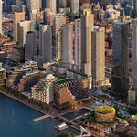
For one, the waterfront lands are far more attractive to any developer than any site available along Queen Street.

Unless you're a developer and not disclosing it, I think you're probably making a baseless assertion here. Personally, if I was a developer, I'd have to think that Queen would be far more preferable because there would be (a) far less risks, (b) lower infrastructure-type costs, and (c) it would be much an easier sell.

Large parcels of waterfront property, close to the core, with the full support of a dedicated city agency, and friendly city policies favouring high density can't compare to a tiny plot hemmed in by low/mid rises on both sides.

Ok, but in the course of your considerations, you may wish to familiarize yourself with the policies of Metrolinx and the province's Places to Grow plan. They're somewhat different than where you're coming from, and ultimately they're what count.

Also, at the end of the sentence you unfortunately revert back to a straw man claim.

Indeed, in about 5 years, we should be getting solid data on what density is developing there and the ridership potential. And its not just waterfront by the way.

Well ok, but do you realize that by saying this you're admitting that your reasoning is based on pure conjecture and speculation?

Can you find an area along Queen that matches what's going on at CityPlace (which if we are assuming 1.5 residents per unit is at over 40k residents per square km and going up to 60k)?

This is where you come closest to making a valid case, except for one crucial detail. Please confirm your population figures.

I should also, however, point out that CityPlace is currently served by three existing streetcar lines and one future one is in the final stages of planning. According to Metrolinx, this would necessarily be viewed as duplication, which precludes funding.

I sometimes think that Queen street proponents are opposed to waiting simply because their scared their case will be blown out of the water by what pops up elsewhere along the city.

You're straw man-ing again here. As far as I can ascertain, Queen proponents are more concrete in their approach and rely far less on speculation and future projections. As an added benefit, this would seem to be more in line with the methodology used by the folks who will fund it.

Finally, the issue of day one ridership. Building them so that they have maxed out on their potential on Day One is bad public policy.

You're straw man-ing yet again in your second sentence. In order to be built, any new transit lines must be fiscally self-sustaining, which means significant Day One ridership. Notwithstanding your straw man claim, however, you are actually inadvertently agreeing that the ridership of a Queen alignment would be very high, or in other words, a success.

But beyond that, high ridership for this line will come not from the locals (that's why despite my paragraphs on development, I still consider it secondary to relief of Yonge-Bloor), but from the commuters diverted from Yonge-Bloor.

Um, are you suggesting it won't be able to recoup its costs then? Again, that's not something that the folks who will pay for it will build.

You want high ridership? Place it right in the core so that most Bloor-Danforth riders choose the DRL over Yonge-Bloor.

Um, nope. I think you're missing the point. What option anyone will choose will depend on where they come from and where they are going. Little things like being able to get a seat or not be crammed will count too. And no matter what the alignment, it'll be in the core.

If you think the Sheppard stubway was a waste of cash, just imagine what people will say when you have to spend another billion to fix Yonge-Bloor a few years after the DRL opens.

Well actually, I think that before too long Bloor-Yonge will need to be renovated no matter what. But, like you, I am convinced that a downtown core subway line that connects with B-D will be beneficial.
 
Northern Magnus: A large portion of your case is based on "real vs projected" evidence. However, you yourself state that Queen has "development potential". Is this not projected evidence in itself? At least CityPlace has concrete plans in place, your evidence is merely "it'll happen someday if we put a subway in".

And I agee with Keithz, the development potential of the Waterfront sites (CityPlace, East Bayfront, etc) FAR exceeds development potential along Queen. I seriously doubt that City Council would let Queen St be turned into Yonge St (ie the pockets of condos the entire way up).

Queen street needs local service in order to be effectively served. This means close station stops, which on a DRL designed to be a faster route downtown, largely negates this purpose. These new communities along the Waterfront can be designed to be Nodal TOD points, as opposed to corridor TOD like Queen St is.

Queen St supporters seem to also be ignoring the fact that a DRL along Wellington (or Front, or King) will bisect Queen St at 2 points, GREATLY relieving the Queen streetcar. It's not as if a DRL someplace other than Queen will not affect Queen at all, far from it.

All plans are based on projections. If you're planning for the now, you aren't really planning.
 
Of course people would walk. I know several people who on occasion walk it from Harbord or Barton/Wallace down to the Bloor-Danforth Line. I myself to save on bus fare choose to walk it from Union to Dundas three times a week. Why must we overanalyse what commuters are willing to do in order to access a high-order mass transit service?

If you'd care to bother reading what I actually posted, you'll notice that I mentioned people already taking the Danforth line and transferring to Yonge...this is the main group targeted by the DRL (though others going other places would benefit) and the reason it'll get built. If someone is already taking the subway and getting off at College or Union, they will not walk along Yonge or University from Queen to College or Union...they will continue to take/transfer to the Yonge line. People won't transfer a second time onto the YUS loop, either, to continue on to a station like College, unless the DRL has no stops along the way and the trains are waiting for them, particularly since the DRL is likely to be pretty much as 'full' as other lines. The reality is that the area to which people will walk from the DRL may not be as big as we think, especially if the DRL does not go north of Danforth. People already on the subway don't pay a second fare. If overanalysis means using common sense, then I guess I'm guilty. Your analysis makes little sense.

Much of the Bloor-Danforth Line has not witnessed mass development. It's only recently that some these lofts/condominums are emerging in spots. That doesn't subtract from the reality that the service attracts 484,000 riders per day. That urban infill and gentrification has occured in some stable neighbourhoods along Bloor, means the same tale could be for Queen Street or any other innercity corridor(s) we prioritized. It won't ruin the neighbourhood either, if anything development could enhance some spots' desirability to live and spend money in.

Again we only need look towards Bloor-Danforth.

Sorry, but Bloor/Danforth is that busy because of the feeder bus routes, like all of Toronto's subway lines and most of its subway stations. And if you're gonna make some vague comparison about total riders, note that gentrification is resulting in population losses in places like Parkdale and Riverdale. One could be optimistic and say the population dropping by thousands or tens of thousands might be offset by aspiring folk going to the Opera House more often, but, no, not really.

But the areas where the CNR cross Queen Street aren't necessarily high-density and will require significant backtracking on the streetcar to make up the travel distance. Just picking a random spot along the corridor that misses areas of higher density isn't beneficial to most.

What backtracking? People coming along Queen from east or west of the DRL would intercept it and be whisked over to the YUS loop in a matter of minutes.

Aren't Wellington and Adelaide de facto King alignments only a block apart? Adelaide is about midaway between King and Queen so it would best satisfy demands for either corridors and not encounter the same level of NIMBY opposition to ROW construction that they face either.

A line being midway between two spots can just as easily offer poor service to both. I said the poll is pointless because it excludes an alignment, which happens to be one of the best alignments. The poll would be different and the entire thread would be different if King was in there and not just ignored.
 
I still don't think the "relief" part of the DRL is a good priority for several reasons. We won't get a second relief line in anyone here's lifetime. No government will ever spend tens of billions of dollars to parallel a subway no less than a few hundred meters away. Not in Toronto, not in Manhattan, not in London, nowhere. Almost out of necessity any new downtown subway will have to serve both the need to relieve overcrowded streetcars along King/Queen as well as improving their connectivity to the rest of the city and relieving overcrowding at Y/Bloor.

"Relief" has several factors going against it. To begin with, the type of crowding at Y/Bloor isn't well suited for relief via subway. Overcrowding is very time and direction specific, being a function of rush hour crowding into and then out of the downtown. Logically, time and direction specific problems should be solved via time and direction specific solutions rather than broad additions of capacity. A "relief" subway would exist 24 hours a day, despite only being necessary for perhaps 2-4 hours, and serve both directions unnecessarily.

A better solution would be more efficient/better downtown express buses along Avenue Rd, Mt, Pleasant & Bayview. Better commuter bus services from STC & NYCC along 400 hwys would also be more efficient at diverting passengers than a new subway. Ultimately, just charging more during congested periods to discourage use is more efficient than building a new subway for "relief" purposes. More creative solutions could involve having government jobs in the core staggered so that employees don't commute during rush hour and offering incentives for business to do likewise.

Despite that, any service that moves faster than a mule would provide some relief for Y/Bloor. I suspect the marginal gains in ridership from reducing en route stations are quite low and rarely exceed the ridership lost from not constructing a given station. We are better focusing on, for instance, using a rolling stock with better acceleration (perhaps hill-profile stations) or designing a better interchange. If, for instance, a Pape interchange was designed to speed up transfers by one or two minutes (cross platform interchanges) that could by itself lead to fairly large diversions from Y/Bloor and render more stations practical. Dragging the line up to Eglinton would also give a lot of relief bang for buck compared to not building stations downtown.

P.S. The general rule of thumb for walking distance is 500m. At typical human walking speeds that means something like 5-6 minutes. Most evidence shows that at or below this distance, people don't consider walking onerous or discourage them from using a given service. Odds are anybody who considers 500m to be beyond walking distance are unlikely to ever take transit in the first place. And even if I am sympathetic to some groups (seniors, disabled) they aren't big enough a demographic to be worth planning around. A rail corridor ROW would have a walking distance limit of roughly the water's edge to King street. An Adelaide walking zone would have a southern limit of the rail corridor and a northern limit of a block or two south of Dundas (the northern edge of NPS or the southern edge of Alexandria Park or Grange Park). People will walk within those zones, creating random examples where a granny is lugging her groceries in the rain are asinine. Just use common metrics.
 
Last edited:

Back
Top