News   May 10, 2024
 706     0 
News   May 10, 2024
 817     0 
News   May 10, 2024
 919     0 

Cycling: West Toronto Railpath (City of Toronto, Phase II Proposed)

^ Which map is out of date? The one in the link I provided or the one in the September 13th presentation?
 
^ Which map is out of date? The one in the link I provided or the one in the September 13th presentation?
I'll find and supply the latest map I'm aware of which shows the 'on-street' northern extension of the path later.

Here's what I'm alluding to:
Toronto's York South-Weston community pursues multi-use Railpath North
Extension would benefit cyclists and people travelling on foot
NEWS AUG 14, 2018 BY LISA RAINFORD TORONTO.COM
[...]
“Part of what reignited our interest in (Railpath North) is the city’s commitment to a St. Clair West SmartTrack station,” Chamberlain said.

Last year, city council adopted a motion to integrate design of the St. Clair-Old Weston Road station with the north-west extension of the West Toronto Railpath. “Serious study” is needed for a Railpath North on the west side of the rail corridor from Gunns Road to the south end of Brownville Avenue with a bridge to alleviate the hill’s severity, Chamberlain said.

“Currently, the only way for cyclists to get from Weston and Gunns Road to Weston and Black Creek (Drive) is a circuitous twice-as-long route via the Lavender Creek path and Hilldale Road, which then requires some way of crossing Black Creek and the busy, narrow Humber Boulevard North at its north end,” he said.

According to the committee, extension north of Osler Street is not up for discussion until design of electrification is complete, in 2022-23.

The additional cost of planning electrification while keeping the option open would be minimal, but not doing so could eliminate a Railpath North altogether, Chamberlain said.
https://www.toronto.com/news-story/...n-community-pursues-multi-use-railpath-north/

In all fairness, this isn't Bailao's ward, but as it stands, the progress on this is glacial at best, and that's when they've melted. If Bailao and associates knew this information, they weren't ready to share any conversation on it.

But on the other hand, the food laid out for the mural unveiling was delicious.
 
I suppose it's good news that they've allocated funding to it, but the timeline is still going to be driven by Metrolinx/the province (unfortunately).
 
By Railpath Extension, they mean the leg from Dundas Street down to King?

Nothing about changes around Bloor to accommodate the GO fourth track?

- Paul
 
By Railpath Extension, they mean the leg from Dundas Street down to King?

Nothing about changes around Bloor to accommodate the GO fourth track?

- Paul
Or evidently the "on street" cycle path connection to the Lavender Creek Trail in lieu of the trackside path north if the "no on-street expansion planned this year" is indeed the case. I'll double check the info later, but as it stands:

I'm just so shocked, shocked I tell you...
July 04, 2018
Cycling Connections at St. Clair and Old Weston

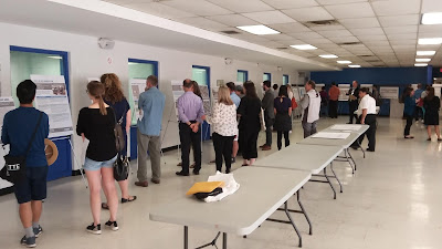
A lot of the Toronto cycling community’s attention on Monday, June 25 was focused on the public meeting debating whether to move the Adelaide protected bike lanes to the left (north) side. However, there was another meeting the same day which has significant potential outside of downtown; that being the St. Clair West Transportation Master Plan (TMP). I had a chance to stop by that meeting on my way home from work to learn more about the transportation issues in that area.


The Lowdown

The City’s display boards cited the Kitchener GO Transit corridor has been a barrier for east-west travel in the St. Clair and Old Weston area with significant congestion issues. This study is concurrent with Metrolinx’s plans to electrify the Kitchener GO Transit corridor, add a SmartTrack station in the area, and build the Davenport Diamond bridge. The City is planning to improve the Dundas-Scarlett-St. Clair area, which will include bike lanes. For the St. Clair West TMP, the City is proposing to do the following along with the necessary building tear downs.
  1. Widen St. Clair from Keele Street to Weston Road
  2. Extend Davenport Road from Old Weston Road to meet Union Street (north of St. Clair)
  3. Extend Gunns Road from Weston Road under the Kitchener line to meet Turnberry Avenue
  4. Extend Keele Street to Gunns Road
Recommended alternatives per the City of Toronto's presentation boards Benefits for Cyclists

From a cyclist’s standpoint, the St. Clair West TMP proposes will provide bi-directional protected bike lanes on the south side of Gunns which will connect with the existing Lavender Creek Trail. The bi-directional bike lanes will then be added to the west side of Union and Davenport. While not in the proposed documents, a city staff member informed me they are considering the possibility of extending the bi-directional bike lanes east from Old Weston to Osler Street; effectively acting as the first step in extending the West Toronto Railpath north.
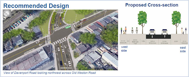
Davenport and Old Weston - Similar design used for Union and Gunns Some painted bike lanes are also called for on Keele Street. Unfortunately, I am concerned about having the bike lane placed between the two turning lanes at Gunns. From what I understand, this was done because that intersection will be controlled by a stop sign instead of by traffic signals.
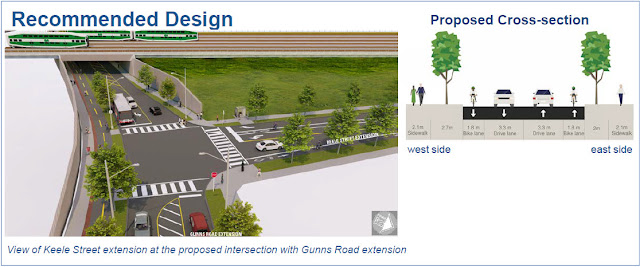
The design of the Keele and Gunns intersection leaves much to be desired Overlooked Drawbacks

Given Toronto’s bike plan had called for bike lanes to be built on Dundas from Royal York to Scarlett – as well as on St. Clair from Scarlett to Runnymede – I was disappointed with the lack of consideration for extending the proposed St. Clair bike lanes from Runnymede to Davenport/Union. This would have helped provide a more direct connection to the existing Davenport bike lanes. Not to mention, the City could have considering extending the Dundas bike lanes from Royal York to the Mississauga border with that city seriously considering protected bike lanes as part of their Dundas Connects study.
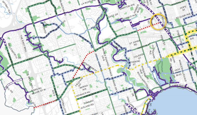
Red lines on bike plan map show missinghttp://twowheelpoli.blogspot.com/2018/07/cycling-connections-at-st-clair-and-old.html Dundas and St. Clair gaps
with the St. Clair West TMP study area circled in yellow Some other advocates I spoke with also suggested using West Toronto Street to extend the Davenport bike lanes; something which was ruled out due to the lack of ability to address congestion on St. Clair. Even with the recommended plan, there remains a concern on how to fill the small gap from the Lavender Creek Trail to the St. Clair – Runnymede intersection.

Final Thoughts

While not without its faults, there is reason to be cautiously optimistic about the St. Clair West TMP from a cyclist’s perspective. With bi-directional protected bike lanes on Davenport, Union, and Gunns, they will contribute in filling a key gap in Toronto’s cycling network and help boost cycling in York-South Weston. The TMP will also help set the wheels in motion for the northern West Toronto Railpath extension as the southern extension gets under way.
http://twowheelpoli.blogspot.com/2018/07/cycling-connections-at-st-clair-and-old.html
 
Last edited:
Not sure if this timeline is actually real, but FWIW TO INView puts construction start in 2020.

Screen Shot 2019-01-22 at 11.03.13 PM.png
 
Interesting response from Tory regarding the Thorncliffe bike lanes considering city staff found well over 90% support for putting the lanes in.
Evidently Tory was close to lying, if not clearly doing so, with that claim. Don't have the tweets up, but follow the prior links, and IIRC the issue was that the complaint wasn't about the lanes themselves, but the lack of their connecting to other major ones.

What Tory was trying to do was change the channel, since he couldn't face up to how his promise, yet again, was baseless.

As to the West Toronto Railpath, the promises for extending north are in total limbo. Any reference to extension is to the south. As it stands, the north end ends nowhere, just dissipates onto side streets in a grotty neighbourhood. They've yet to even paint the on-street bike lanes promised in lieu of a proper trail.
 
Jan 18
This is how Metrolinx lives up to its promises of keeping the sound barrier clean after being tag. This is Dufferin overpass for RailPath, but can be found along corridor anywhere today
46809336241_f461d5f5a9_b.jpg

45894119465_c8c90c6b70_b.jpg
 
Presentation slides from last week's stakeholder meeting are up:

Some notes from the meeting:
  • The existing access ramp north of Dundas is planned to be re-graded for AODA compliance and to improve sight lines. This project will have property impacts on the lot where the High Park Parkdale Employment & Social Services building is located, owned by Nestlé, with whom the city is currently negotiating. Hopefully the changes will fix that scary blind corner.
  • The bridge over the Barrie Line is being built with provisions for a connection to a future bridge across the Kitchener line to Sorauren Park. That bridge may be built in connection with the Wabash Community Centre project, which has $40 million in funding and is currently being designed.
  • An accessible connection through the No Frills parking lot was initially contemplated, but was removed from the EA due to 11th-hour opposition from No Frills relating to parking impacts. However, the city is once again in discussions with No Frills and Choice Properties, owners of the land, and there is hope that a resolution will be found. (If not, the city expects that this property will likely be redeveloped in the medium term and any new development would be required to provide a railpath connection.)
  • The connection at Northern Ave is proposed to be changed to a pedestrian-only connection with no plaza due to opposition from neighbours. Practical effects will be minimal since anyone travelling from the east or north would likely be using St Clarens and anyone coming from points west would be using the Lansdowne connection.
  • Since nobody seems to have any idea what's going on with SmartTrack, the planning around the King-Liberty SmartTrack station is on hold for now, pending some clarity from the province. The railpath team hopes that there is news on this before the design is complete so the entire project can be tendered at once, but that may not be possible, and they are prepared to build the portion south of Queen separately if necessary.
  • The new path will be 3.6m wide except for a few narrow sections which will be ~3.5m wide, and will have a yellow centre line painted.
  • Bridge designs have been updated with feedback from the last open house and are now painted orange to match the existing bridges. The opaque side panels on the Barrie Corridor bridge have been opened up with alternating plexiglass segments for better views (there is a Metrolinx requirement for hard barriers up to 2m on either side due to electrification infrastructure).
  • The big question, timeline! Lots of conflicting signals. One of the engineering reps said that the contract for corridor grading and noise wall construction is expected to wrap up in fall 2020, at which point construction on the railpath presumably could begin while rail-related construction continues on the other side of the noise wall until 2024. Then another rep from Metrolinx said that they were still working with the contractor to determine timelines and that they were not sure when the prep work would be done.
  • Depending on the results of the next election, it is hoped that federal infrastructure funding can be secured. The project team is preparing a backup plan to fund the project using city sources if the federal funding falls through. The railpath extension did previously receive $11 million in PTIF funding, but due to the expiry of the spending deadline, most of that funding was redirected to other projects (~$1.5 million, IIRC, was retained to pay for the design work that is now underway).
 
Jan 18
This is how Metrolinx lives up to its promises of keeping the sound barrier clean after being tag. This is Dufferin overpass for RailPath, but can be found along corridor anywhere today
46809336241_f461d5f5a9_b.jpg

45894119465_c8c90c6b70_b.jpg

I'd say the path looks good except for the parts that were witewashed by the city and haven't been tagged back over.
 

Back
Top