|
|
|


Search results
-

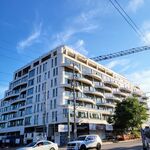
Toronto Waterworks Building Redevelopment | 47.55m | 13s | MOD Developments | Diamond Schmitt
Article in today’s G & M: https://www.theglobeandmail.com/real-estate/toronto/article-from-architectural-caterpillar-to-art-deco-butterfly-waterworks-food/- thecharioteer
- Post #832
- Forum: Buildings
-
Miscellany Toronto Photographs: Then and Now
Great post!- thecharioteer
- Post #15,760
- Forum: Photos and Videos
-
Toronto Waterworks Building Redevelopment | 47.55m | 13s | MOD Developments | Diamond Schmitt
Then and Now: 2016: Last night:- thecharioteer
- Post #797
- Forum: Buildings
-
Miscellany Toronto Photographs: Then and Now
Mirvish Village 1982: May 2024 (pic by ADRM): 1980's: May 2024 (pic by ADRM):- thecharioteer
- Post #15,756
- Forum: Photos and Videos
-
Toronto In Art
Also from the Ingram Gallery website, this 1926 linocut by Charles Comfort showing houses in the Ward (probably Louisa Street) with the Old City Hall behind. Comfort designed the frieze on the old Stack Exchange. CHARLES COMFORT, R.C.A. (1900–1994) December, c.1926 linocut, ed. 12/30 8.25 x...- thecharioteer
- Post #79
- Forum: Photos and Videos
-
Toronto The One | 328.4m | 91s | Mizrahi Developments | Foster + Partners
View from 55C:- thecharioteer
- Post #17,506
- Forum: Buildings
-
Miscellany Toronto Photographs: Then and Now
I'm amazed that what is now the Hampton by Hilton at 300 Jarvis has been so badly treated and renovated (windows, lower level, stonework, etc.) given that it is subject to both heritage designation and a heritage easement agreement. Does no one pay attention at Heritage Preservations Services...- thecharioteer
- Post #15,754
- Forum: Photos and Videos
-
Miscellany Toronto Photographs: Then and Now
Havergal Ladies College: Jarvis Street : 1906: (1906-1916): As a CBC building 1967 (TPL): Today (now the National Ballet School). Pic by Rascacielo:- thecharioteer
- Post #15,753
- Forum: Photos and Videos
-
Miscellany Toronto Photographs: Then and Now
Dundas looking east from Yonge 1978: Now (taken by UT's A Torontonian Now):- thecharioteer
- Post #15,752
- Forum: Photos and Videos
-
Miscellany Toronto Photographs: Then and Now
Same view 1980:- thecharioteer
- Post #15,751
- Forum: Photos and Videos
-
Yonge Street Revitalization (Downtown Yonge BIA/City of Toronto)
Now these are crowded sidewalks:- thecharioteer
- Post #1,304
- Forum: Design and Architectural Style
-
Miscellany Toronto Photographs: Then and Now
Interesting question. This postcard shows the sign and given that the streetcar tracks were removed in 1966 and the ManuLife Centre started construction in 1970, it was at least there during this period.- thecharioteer
- Post #15,746
- Forum: Photos and Videos
-
Miscellany Toronto Photographs: Then and Now
And the Britannica building opened in 1962.- thecharioteer
- Post #15,744
- Forum: Photos and Videos
-
Miscellany Toronto Photographs: Then and Now
Bloor looking east at Avenue Road: Early 1960's: Now (photo by Blixtein on The One thread):- thecharioteer
- Post #15,741
- Forum: Photos and Videos
-
Miscellany Toronto Photographs: Then and Now
A good illustration of the homoginization of Yonge. Nostalgia aside, gone are the free-standing cinemas, live music, record stores, book stores, bars, clubs, one-off restaurants, mom-and-pop stores, piano and music stores, bowling alleys and department stores.- thecharioteer
- Post #15,739
- Forum: Photos and Videos
-
Miscellany Toronto Photographs: Then and Now
Another view west in 1915:- thecharioteer
- Post #15,735
- Forum: Photos and Videos