Toronto Ontario Line 3 | ?m | ?s

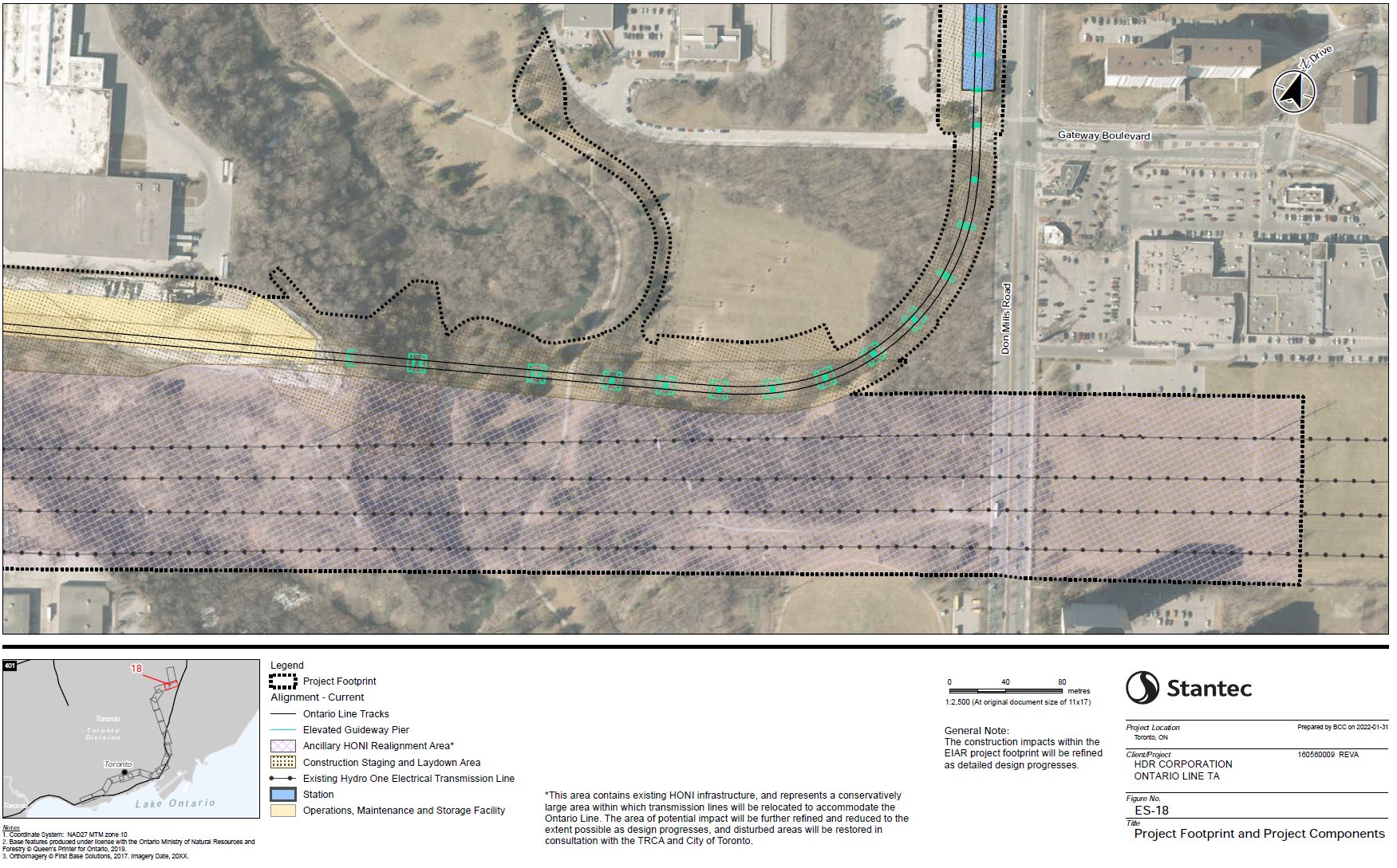
The issue is the definition of bridge. The bridge is short and barely crosses the river and is completely straight. The rest is defined as elevated guideway and curves.

Great map! Thank you for that.

Okay now I gotta ask, what's the difference between a 'bridge' and an 'elevated guideway' to a lay person staring up at it from the valley floor?
 
Okay now I gotta ask, what's the difference between a 'bridge' and an 'elevated guideway' to a lay person staring up at it from the valley floor?

I don't expect the average person will notice any difference other than that one piece is little longer than the rest.

It probably doesn't make a noticeable difference to engineers either as every span between pylons is a bridge, and no span is unusually difficult. The entire elevated section is made of contiguous bridges of various lengths and heights.

The bridge/elevated definition change is probably for budget estimation purposes. The longer/taller span will require some additional support.
 
Last edited:
oldraftea_footprint_18_donmillscurve.jpg

It's funny that the station RIGHT IN FRONT of the Science Centre is Flemingdon Park and that the actual Science Centre station is north of Eglinton about a 10 minute walk to the Science Centre's front doors.

Of course there's a good chance the Science Centre will have moved by the time the line opens, but there's a good chance Ford will be out and the next government (likely Liberal) will leave it where it is.
 
The span of the bridge is straight and there will be a curve after the span on the elevated portion of the line.

That said, the main bridge span crosses a fairly short section of the ravine, so the elevated curve begins well before Don Mills. It's gentle enough there should not be a speed reduction. Potential pylon placement was documented somewhere though I can't find it at the moment.

Edit: Found the pylon location map:
oldraftea_footprint_18_donmillscurve.jpg
Jheez, that curve towards Don Mills looks almost as tight as the SRT curve towards Kennedy!
 
Nature must be conquered?

Screenshot 2024-03-10 at 2.48.01 PM-2.jpg

Screenshot 2024-03-10 at 2.48.17 PM.jpg

Screenshot 2024-03-10 at 2.47.38 PM.jpg

Screenshot 2024-03-10 at 2.51.22 PM.jpg
Screenshot 2024-03-10 at 2.48.31 PM.jpg
Screenshot 2024-03-10 at 2.51.30 PM.jpg
Screenshot 2024-03-10 at 2.52.00 PM.jpg
Screenshot 2024-03-10 at 2.56.22 PM.jpg
Screenshot 2024-03-10 at 2.56.34 PM.jpg
 

Attachments

  • Screenshot 2024-03-10 at 2.47.07 PM.jpg
    Screenshot 2024-03-10 at 2.47.07 PM.jpg
    247.6 KB · Views: 19
  • Screenshot 2024-03-10 at 2.51.52 PM.jpg
    Screenshot 2024-03-10 at 2.51.52 PM.jpg
    172.1 KB · Views: 13
  • Screenshot 2024-03-10 at 2.55.45 PM.jpg
    Screenshot 2024-03-10 at 2.55.45 PM.jpg
    226.6 KB · Views: 18
  • Screenshot 2024-03-10 at 2.51.22 PM.jpg
    Screenshot 2024-03-10 at 2.51.22 PM.jpg
    230.6 KB · Views: 96
  • Screenshot 2024-03-10 at 2.48.01 PM.jpg
    Screenshot 2024-03-10 at 2.48.01 PM.jpg
    286.2 KB · Views: 21
  • Screenshot 2024-03-10 at 2.47.38 PM.jpg
    Screenshot 2024-03-10 at 2.47.38 PM.jpg
    245.9 KB · Views: 24
Last edited:
Before:

Screenshot 2024-03-10 at 9.19.12 PM.png


After:
Screenshot 2024-03-10 at 2.48.17 PM.jpg

Screenshot 2024-03-10 at 2.51.22 PM.jpg


The real shame is the last photo where the river curves around. The bridge won't go across there. They just cut all those trees down so they have room to work or stage materials and equipment. Necessary I guess, but even with replanting those trees won't be like that again until 2050 or 2060.
 
Before:

View attachment 547244

After:
View attachment 547245
View attachment 547246

The real shame is the last photo where the river curves around. The bridge won't go across there. They just cut all those trees down so they have room to work or stage materials and equipment. Necessary I guess, but even with replanting those trees won't be like that again until 2050 or 2060.
The last 2 pictures are not after. They are during. After is once construction has been completed and they have had a chance to go back and landscape it.
 
  • Angry
Reactions: PL1
The last 2 pictures are not after. They are during. After is once construction has been completed and they have had a chance to go back and landscape it.

Hahah. Okay. Sure thing.

They are AFTER the clearing.

If you'd like to post the after the construction, after the landscaping, after it has grown to where it was before, I'll check back here in 30 years for a true after shot.

😆
 
Last edited:
Hahah. Okay. Sure thing.

They are AFTER the clearing.

If you'd like to post the after the construction, after the landscaping, after it has grown to where it was before, I'll check back here in 30 years for a true after shot.

😆
If you noticed, I said 3 different times. If that last picture is 10-30 years from now, then that is when it is to be.
 

Back
Top