News   Apr 30, 2024
 39     0 
News   Apr 30, 2024
 330     0 
News   Apr 30, 2024
 850     0 

Some GTA Aerials by Tim MacDonald (Covid19 induced Boredom)

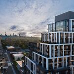
South, North and East views from Port Credit GO. Westport condo in the frames 1 and 3 nearing completion after almost three years of construction.
1701866181731.jpeg

1701866203918.jpeg

1701866229217.jpeg
 
Erindale United Church, University of Toronto-Erindale campus, and of course, MCC.
1702039733997.jpeg
 
This is the Southeast corner of Dundas and Mississauga road. There is a development planned for this parcel and details are here:https://urbantoronto.ca/database/projects/2935-and-2955-mississauga-road.48206

Across Mississauga road and up the embankment just above my name is another development planned for the industrial looking building: https://urbantoronto.ca/database/projects/carmel-heights-seniors-redevelopment.51046

Off in the distance is the Sheridan Mall which was since been renamed to something I have totally forgotten. Condo towers are planned for some of the peripheral parking lots.
 
Yes, that was close where the photo was taken! I'll check the original photo and post the position.

Pretty accurate - here is the actual location of the photo, but not the takeoff location:
1702429463947.png


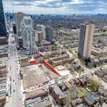
Wanted to give myself a bit of a challenge with my next geolocation, so I picked this shot without any major identifiable landmarks other than what I assumed was Mississauga skyline way off in the distance:


Geolocated to the corner of Southdown Rd & Royal Windsor Dr, next to Clarkson Go station:
View attachment 526654
 
The current wasteland that is Dundas Street from Shorncliffe road to East Mall Crescent.
1702476158192.jpeg
 
Dundas and Bloor in Etobicoke continues to evolve. Construction on the new Etobicoke Civic Centre in the lower left is visible.
1702574394522.jpeg
 
Dundas and Bloor in Etobicoke ...
At least you told us which "Dundas and Bloor" this was (I would assume most of us would know from the photo anyway), unlike the radio news and traffic reports that leave people guessing whether the fire or blocked intersection they should avoid is there or the one near the GO/UPX station. 🤣
 

Back
Top