I agree almost entirely! The only thing is that I would put a proper station directly under Pearson Airport, rather than on the existing GO Weston sub.
This may be getting a bit off-topic but my idea with transportation around Pearson was to keep the electrified high speed rail corridor on the Georgetown rail corridor, and then build a HSR station/mobility hub at Malton. A mobility hub would also be built at Renforth/Eglinton to meet up with the 401/427 the Eglinton Crosstown LRT (Subway) and whatever busway Mississauga is building. To get an idea of what this looks like,
click here.
A dedicated Airport rail transit line could then be built between Malton and Renforth and would be free to use between these stops. Free boarding works for this kind of line because both terminals are pure transfer nodes and would require someone to either drive there or pay an adiitional fare to arrive there. There are very few people who would be riding this line whose point-to-point origin or destination are on the line. The line can be made free to ride through subsidies collected from the airport, gas tax, and connecting service.
Baggage checking/retrieval service could also exist at all of the stops to make it easier for people to switch modes and would also provide more options for drop-off and pick-up around Pearson.
The main problem that I see arising with locating the main station adjacent to the Pearson terminal is the additional traffic congestion caused by drivers and GO buses needing to go out of their way enter the terminal area in order to park or drop off passengers. Terminal 1 is a bit out of the way for many potential passengers, and was one of the reasons the Square One-Pearson GO service was discontinued.
There is also the cost factor of building a completely new electrified through heavy rail corridor through this area due to the number of grade separations that would be needed and properties acquired to maintain high-speed service along the branch. To contrast, the existing Georgetown line is almost dead straight and would only need slight curve adjustments.
A new through rail corridor to Pearson would also make the new Air-Rail spur completely obsolete, as the new through route would be more direct and faster. Although, now that I think about it, much of the spur could be re-used in an Eglinton LRT/Finch LRT connection.
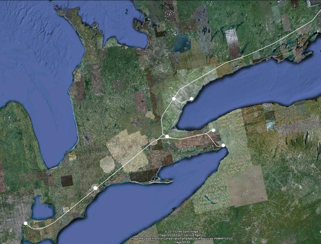
I've been wondering about which corridor (via Kitchener or via Burlington) is the best to use for the HSR between London and Toronto. Although is probably more population along the route via Kitchener, it is located in closely spaced cities such as Kitchener/Waterloo, Guelph, and Brampton. As well, the Weston Subdivision is less ideal for HSR than the Oakville Subdivision, mainly because between Georgetown and Toronto there is significant freight traffic, and there are some fairly major pinch points, such as the one at Brampton Station.
At the moment, I'm thinking that the Kitchener corridor would be best served by frequent regional rail service between Union and London*, rather than HSR. The HSR would go through the countryside from London to Burlingon, where it would join the Oakville Subdivision, which would be fully quad-tracked in an express-local layout. Express stations would be Burlington, Oakville and Port Credit, and HSR trains would probably stop at only one of them, but passengers would be able to easilly access the entire corridor thanks to frequent service on the Lakeshore West line. Express GO trains from Niagara Falls or Hamilton would serve all 3 express stops in the corridor (in fact, the Niagara Falls trains already do!).
* Stops: London, St. Mary's, Stratford, Kitchener/Waterloo, Guelph, Georgetown, Brampton, Pearson Airport, Mount Dennis (Weston @ Eglinton) or Bloor, Union
I'd say that Hamilton-Toronto and Kitchener-Toronto are both equally important potential high-speed corridors, but as far as a mainline goes I think the northern route beats it out. Hamilton's population centre would be a detour away from the mainline while KW's is not. Waterloo Region's population has just passed London's and is set to meet or pass Hamilton's. There are also less issues with crossing the escarpment with a northern route. Although, being from Waterloo Region, I could be a bit biased.
High-Speed rail corridors would still be capable of running local service. The Guelph Subdivision does not see all that much freight traffic and could definitely handle more passenger trains with double-tracking strategically in the short term and triple-tracking when HSR is built.
[rant]
Of course all of this High-Speed rail talk is dependant on the pressure to change Transport Canada's Policy on vehicle weight and attitude towards centralized train control. I think its a bit ridiculous that our locomotives and rolling stock need to be overbuilt in order to be salvageable in the event of a collision, instead of having a train system which simply avoids collisions in the first place. This means we have to not only spend more to build the trains, but also spend more to operate them, as it takes much more energy to move a steel brick than an aluminum lattice.
Just imagine if we built automobiles (which don't even run on collision-preventing tracks) to that standard. A typical armoured compact would cost $50,000 and very few would be able to afford the gas to run the thing.
This is not only a problem for High Speed Rail, but for potential light rail corridors as well. There are instances where corridors that could be utilized by EMU service already exist, but would be uneconomical due to the unnecessary additional costs placed on both purchasing and operating the vehicles.
[/rant]
From these maps, it's impossible to tell the radius of the turns, so I don't know how you can accuse both of being unreasonable. A while ago took a very detailed look in Google Earth along the entire route I prefer (which happens to be the same as the one proposed by dunkalunk), and there wasn't really anything that struck me as a major impediment to a High Speed Railway. Obviously Google Earth is not detailed surveying equipment, but the point is that dunkalunk's routing seems reasonable. I don't think as much detail was put Canadian National's map, but I think the point was to display the general routing, rather than the specific one.
Thanks for that, If i knew how to use ArcGIS for this sort of thing and had the free map/image data, I would. Google maps has been having bug issues with editing lines, text fields, and changing shape colours lately that are yet to be resolved after a couple of months.`