Toronto Arcadia District | 138.4m | 42s | Ellis Don Developments | BDP Quadrangle

AlbertC

Superstar
Member Bio
Joined
Apr 24, 2007
Messages
23,210
Reaction score
63,742
Location
Davenport


56 FIELDWAY RD
Ward 3: Etobicoke-Lakeshore

Application Number:
21 205810 WET 03 OZ
Application Type:
Rezoning
Date Submitted:
30/08/2021
Status:
Under Review

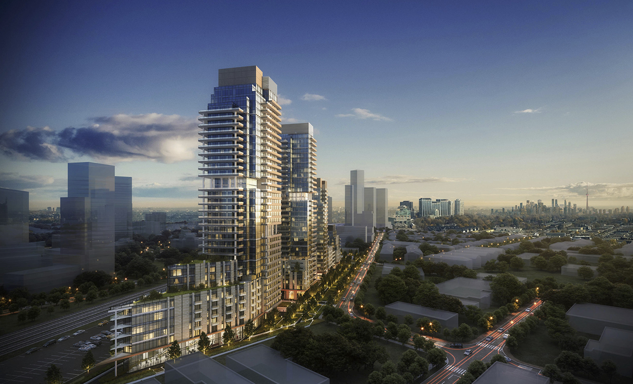
Proposed redevelopment of the site into a mixed-use community comprised of a wide range and mix of residential units, new office and childcare uses, a new public park, two pedestrian POPS pathway connections and large outdoor open spaces and landscaped areas that will serve the existing and future residents of the area. The proposed redevelopment is made up of one 10-storey mid-rise building and three tall budlings, 22, 32 and 35 storeys. The proposal introduces a total of 1,149 new residential units in a mix of studio, one-, two- and three-bedroom units (including grade related units), as well as indoor and outdoor amenity areas within each building. The proposal also includes a total of 935 square metres of office space, as well as 432 square metres of childcare space. The total gross floor area of the development is 91,397 square metres, resulting in an overall density of 5.3 FSI.

stowe.JPG
stowe2.JPG
stowe3.JPG
stowe4.JPG
stowe5.JPG
stowe6.JPG
 
Connecting this stretch to the Kipling/Etobicoke Downtown Hub over the tracks will require some creativity. Right now it is a nasty, terrible walk. I'm happy with the density proposed here. Overall this is on the right track even though I suspect it may be a rezoning play by the car dealer conglomerate family. I hope this can attract some more mix of uses over time with the new Etobicoke City Hall and can follow in the tracks of North York City Centre . Lots to be excited about in this part of the City!
 
Connecting this stretch to the Kipling/Etobicoke Downtown Hub over the tracks will require some creativity. Right now it is a nasty, terrible walk. I'm happy with the density proposed here. Overall this is on the right track even though I suspect it may be a rezoning play by the car dealer conglomerate family. I hope this can attract some more mix of uses over time with the new Etobicoke City Hall and can follow in the tracks of North York City Centre . Lots to be excited about in this part of the City!

On the subject of a connection across the tracks, the Planning Rationale Report has this to say:

1631121413848.png


Also from the Planning Rationale Report:

1631121542560.png


Site will accommodate 6 carshare spaces

Plans allow for a spot for Bikeshare should the City extend it that far.

*****

@smallspy, do you know how well used this rail spur is?

I see it looks well maintained and appears to service, maybe 3 customers?

I'm just wondering about its future as it gets encroached on by residential, and also as Fieldway becomes a very high traffic road.
 
Last edited:
I'm all for residential builds, but I really dont like how this is encroaching on industrial lands.

Yes this is Etobicoke City Centre, but we've all seen how this story goes once dense developments start to encroach on lands (ie: more and more industrial lands in the immediate area gets lost). If we are going to have residential builds in this area, there really needs to be a creative use of what else will be included in the builds (ie: art spaces, food co-ops, food kitchens, etc). This proposal doesnt cut it for me, and the office space proposed here will be next to useless.

As for the overall design, this is a complete miss.
 
I kind of get the feeling Etobicoke Centre is on the cusp of exploding with tall residential proposals similar to the Yonge and Eglinton area for the past decade...

The industrial lands to the immediate south take up an amount of space close in size to all of downtown Toronto. Future development pressure will put the city's determination to keep those "employment lands" as is to the test.
 
Agreed with the above comments generally; this needs more creative thinking to provide actually attractive and flexible employment space… and I wonder if maybe what's integrated into the base of these buildings, given the industrial landscape (including the surface parking alongside the rail corridor to the immediate north) might not be made appropriate for the food producer and importers that dot the area to the south, along with artists/makers studios. We don't just need affordable housing, we need affordable employment space too (which the aging industrial area here provides to a degree), and maybe that shouldn't be lost if and when this gets redeveloped.

42
 
Love the second photo from the top! Viewing this development in foreground and the downtown core in the back. Showing the impact of density in the future for Toronto.
 
I wonder if the sprawling, single-storey suburban warehouse will become a thing of the past in Toronto as demand for land intensifies. There's a 1960s industrial complex at the north end of the Junction, 500 Keele Street, that has two storeys of loading docks for semi trucks. If housing is going vertical, why not build multi-storey warehouses and factories? It's already happening in the self-storage industry.
 
I wonder if the sprawling, single-storey suburban warehouse will become a thing of the past in Toronto as demand for land intensifies. There's a 1960s industrial complex at the north end of the Junction, 500 Keele Street, that has two storeys of loading docks for semi trucks. If housing is going vertical, why not build multi-storey warehouses and factories? It's already happening in the self-storage industry.
That would be nice with light industries that don't have to deal with noise regulations for industrial vehicles etc. And not creating bad air quality situations for the other tenants as well.
 
UT article with a summary on this project:

 
Not my best shot but here is one of the property from Oct 31.I had mistakenly believed that the parking lot was part of the subject property so my composition is off and I have cut off the east end of the property
.
DJI_0118e.jpg
 
Love the second photo from the top! Viewing this development in foreground and the downtown core in the back. Showing the impact of density in the future for Toronto.
I live right nearby this new development proposal and this second photo is extremely misleading. I understand the artistic license taken by the firm to render and sell the proposal but it makes no sense. I'll post drone photos to match the perspectives rendered.

What's also lost in the renders is the CP Spur rail line. Moving into the area, it appeared defunct as there is little to no rail safety signage or indicators of a train. To my surprise, that rail line is most definitely in use more than I ever anticipated. CP Rail maneuvers huge cars on the south side of Fieldgate because the track splits and you can park box cars. The park proposal makes no sense considering the safety issues around an active rail line. A large wall would need to be built on either side of the rail lines bisecting the developments.

I hope this means the plan to put in a pedestrian bridge over the rail lines comes to fruition. It's a long crappy detour to get around the area.
 
More photos from today of this site:

Looking along Fieldway - rail line visible roughly where the white van is parked on the street.
DJI_0491.JPG


Off centre showing distance to Downtown
DJI_0492.JPG
 
This looks like a great development proposal... I am also real excited by it the larger context of the surrounding high-density development in the area.
 

Back
Top