

R
ronald1987
Guest
I've never shown any pictures of the Hague here.
So it's about time I make up for the lack of pictures of this great city. Today I went to The Hague, and the pictures bellow are the result of my two-hour walk through the central parts of Holland's densest major city.
In september, a new subway line (a lightrail line actually) between downtown Rotterdam and The Hague opened.

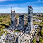
The entire line isn't finished yet, you can travel until suburban The Hague (seen here), from there, there is a direct bus line to the Hague central station.


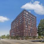
The ministry of Mobility, Spatial Ordening, and Environment directly next to Central Station


Inside the Ministry

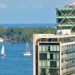
Outside the ministry, we're now amongst the Hague's tallest skyscrapers.

These are commonly reffered to as 'the tits of the Hague'

Het Strijkijzer

Entrance of the building pictured above

Typical Dutch channel, 21st Century-style.

The ministry of spatial ordening, with a tramway passing through it.

A similar set-up can be found in Canary Wharf, London.

Courtyard in the ministry of public health and sport.


It's been awhile since I last made a decent photoreport, that's why my pictures might not be as sharp and bright as I want to.


Trams are everywhere.


Zoomed in a bit.


Walking towards City Hall.

This is typically the Hague, really.

Entrance to City Hall

Inside City Hall!

From the 11th (the highest) floor:


These shots were taken from a restriced area, but I got lucky because somebody in there had allowed me to come inside their office and take some pictures!


In the thread 'Rotterdam II', you can see the Hague's skyline from the top of a Rotterdam Skyscraper.
Now you can see Rotterdam's skyline from the top of a the Hague skyscraper!


Trams seen from 11 floors up.

So it's about time I make up for the lack of pictures of this great city. Today I went to The Hague, and the pictures bellow are the result of my two-hour walk through the central parts of Holland's densest major city.
In september, a new subway line (a lightrail line actually) between downtown Rotterdam and The Hague opened.
The entire line isn't finished yet, you can travel until suburban The Hague (seen here), from there, there is a direct bus line to the Hague central station.
The ministry of Mobility, Spatial Ordening, and Environment directly next to Central Station
Inside the Ministry
Outside the ministry, we're now amongst the Hague's tallest skyscrapers.
These are commonly reffered to as 'the tits of the Hague'
Het Strijkijzer
Entrance of the building pictured above
Typical Dutch channel, 21st Century-style.
The ministry of spatial ordening, with a tramway passing through it.
A similar set-up can be found in Canary Wharf, London.
Courtyard in the ministry of public health and sport.
It's been awhile since I last made a decent photoreport, that's why my pictures might not be as sharp and bright as I want to.
Trams are everywhere.
Zoomed in a bit.
Walking towards City Hall.
This is typically the Hague, really.
Entrance to City Hall
Inside City Hall!
From the 11th (the highest) floor:
These shots were taken from a restriced area, but I got lucky because somebody in there had allowed me to come inside their office and take some pictures!
In the thread 'Rotterdam II', you can see the Hague's skyline from the top of a Rotterdam Skyscraper.
Now you can see Rotterdam's skyline from the top of a the Hague skyscraper!
Trams seen from 11 floors up.


")