News   Apr 16, 2024
 313     0 
News   Apr 15, 2024
 1.2K     0 
News   Apr 15, 2024
 2.5K     6 

Old Toronto Architecture, Plans and Maps

What a fantastic website. They even have shots from Commerce Court North's observation deck! I wish I can somehow get access to go up there....love those huge heads.
 
Now that's how you welcome visitors....not advertisements mowed into lawns.

3a-18.jpg
 
I had been thinking that UT needed a thread for map geeks like me, but I figured there probably already was one.

Much of what will follow has probably been mentioned or posted previously in other threads, but a central repository might be handy, for future reference.

http://digital.library.mcgill.ca/CountyAtlas/images/maps/townshipmaps/yor-m-york-se.jpg

http://digital.library.mcgill.ca/CountyAtlas/images/maps/townshipmaps/yor-m-york-sw.jpg

Fellow map geeks, jump in at any time! I currently have no offsite image account, so I can't make automagic images appear. For now, it'll just be links and attachments.


Great idea! Why not just open a free account at photobucket and you can post your own pics?
 
Charioteer,

I will probably get around to it eventually, but I have no internet access at home, so I do all this at work, and my traffic can be monitored. I feel it's best to keep my wwweb activity low, for the time being.

This kind of thing can quickly become addictive...and distracting! :)
 
I had been thinking that UT needed a thread for map geeks like me, but I figured there probably already was one.

Much of what will follow has probably been mentioned or posted previously in other threads, but a central repository might be handy, for future reference.

http://digital.library.mcgill.ca/CountyAtlas/images/maps/townshipmaps/yor-m-york-se.jpg

http://digital.library.mcgill.ca/CountyAtlas/images/maps/townshipmaps/yor-m-york-sw.jpg

Fellow map geeks, jump in at any time! I currently have no offsite image account, so I can't make automagic images appear. For now, it'll just be links and attachments.

WWWebster - Do you know what date those maps are?
Thanks
AmJ
 
WWWebster - Do you know what date those maps are?
Thanks
AmJ

The McGill site says: Between 1874 and 1881, approximately forty county atlases were published in Canada, covering counties in the Maritimes, Ontario and Quebec. Thirty-two of these atlases were produced for Ontario by the following five companies: H. Belden & Co. (17); H.R. Page & Co. (8); Walker & Miles (5); J.H. Meacham & Co. (1); H. Parsell (1). Two types of county atlases exist for Ontario, those which covered a single county or multiple adjacent counties, and those which were published as supplements to Dominion of Canada atlases. In total, 40 Ontario counties were covered by these 32 atlases.
 
Thank you!

The McGill site says: Between 1874 and 1881, approximately forty county atlases were published in Canada, covering counties in the Maritimes, Ontario and Quebec. Thirty-two of these atlases were produced for Ontario by the following five companies: H. Belden & Co. (17); H.R. Page & Co. (8); Walker & Miles (5); J.H. Meacham & Co. (1); H. Parsell (1). Two types of county atlases exist for Ontario, those which covered a single county or multiple adjacent counties, and those which were published as supplements to Dominion of Canada atlases. In total, 40 Ontario counties were covered by these 32 atlases.

Thanks for the information DSC, and for the original post. The SW map is fascinating. I love old maps of familiar places. :D
 
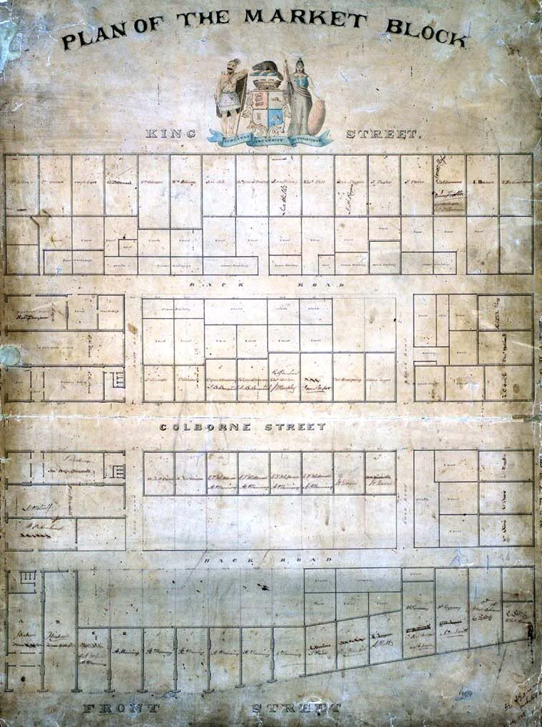
Here's one of my favourite maps, the Market block (between Church and Market Streets) by John Howard, dated 1848 (Toronto Public Library collection), today mostly occupied by the condo project Market Square:

howard-819_m.jpg
 
... a year before the first Great Fire destroyed the Cathedral and the buildings located between King, Adelaide, Church and George Streets.
 
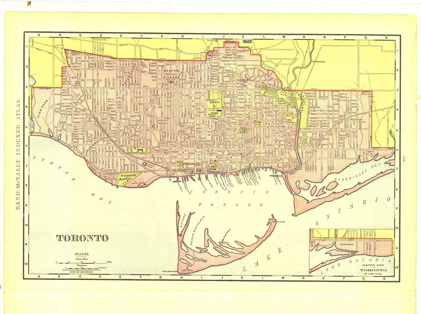
Here's another one, dated 1898 on the bottom; after the new Provincial Legislature is built, but before the "Old" City Hall on Queen. Large size, but worth it for the detail, particularly of the "suburbs" north of Bloor and east of the Don:

Historical_Map_of_Toronto.jpg
 
AmJ,

Sorry, I should have mentioned that. I believe the York County Atlas was 1878.

More of the area surrounding those two maps at:

http://digital.library.mcgill.ca/countyatlas/york.htm

1878 - Thanks! As you might guess from my "handle" I live in the West End which was just beginning to be developed at that time I guess. The lot and road layout in my area turned out to be completely different to the "plan" in this Atlas. I have seen some slightly later fire insurance maps which are a hybrid between this early map and the current situation. There sure was a lot of change very rapidly in this area between 1880 and 1930. I wonder how much documentation there is about why and who determined the road layouts... I might get time to investigate when I retire in twenty-odd years I guess :rolleyes:
Thanks again!
 

Back
Top