News   Apr 15, 2024
 901     0 
News   Apr 15, 2024
 2K     5 
News   Apr 15, 2024
 644     0 

Lost Road: Historic route of Dundas Street though the Niagara Escarpment?

Transportfan

Senior Member
Member Bio
Joined
May 4, 2007
Messages
2,331
Reaction score
858
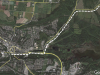
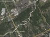
Dundas St. runs from Toronto west to London. It was also known as Governors Road historically and is still known as that in parts between the former town called Dundas and Paris. To reach Dundas, the street would have had to cross through the escarpment from Waterdown. There are a few roads, Olympic Dr., York Rd., Snake Rd., and a few shorter ones, that look like they might have formed the original Dundas St., with the piece of current Dundas (former Highway 5 west of the possible original cutoff) being a bypass.

From Google Earth. Western section in Dundas:

Dundas1.png


Eastern Section in Waterdown:

Dundas2.png
 

Attachments

  • Dundas1.png
    Dundas1.png
    1.1 MB · Views: 1,278
  • Dundas2.png
    Dundas2.png
    1.1 MB · Views: 1,481
What interests me is the route of Dundas Street between Woodstock and London. Did it always follow Highway 2, or did it previously go through Beachville and Ingersoll, becoming Hamilton Road in London?
 
Until the 70s/80s, the latter *was* the route Hwy 2 took--at least to Ingersoll and then up to Thamesford.

As for Hamilton Road, it's plausible--wonder if it's a W Ontario counterpart to the Danforth Road situation in E Ontario?
 
Last edited:
Dundas or Highway 5 is actually very old, one of the three first Ontario arterials, Yonge Street and Highway 2 (the King's Highway or Lakeshore Rd.) being the other two. Highway 5 ended at Queen and Ossington, at the Insane Asylum! It runs to the armoury in London, which was intended to be the capital of Ontario. It's interesting that a few towns were in mind as Ontario's capital prior to Toronto and Newark (Niagara-on-the-Lake): Coburg, Kingston, and London. Kingston was for a while the capital of Canada West. Toronto definitely has the geography though, being a naturally sheltered harbor at the mouth of three major rivers and located at the bottom of an almost continuous strip of land running north. London is nicely tucked away though between the lakes. Basically the agriculture and development of Western Ontario was made possible because of Highway 5.
 
But Hwy. 5 isn't the same as Dundas St. West of Dundas (the former town) it jogs south and leaves Hwy. 5 and is called Governors Road. And from Paris west, Dundas follows Hwy. 2.

But the mystery remains: Where did Dundas pass through the escarpment?
 

Back
Top