News   Apr 25, 2024
 469     0 
News   Apr 25, 2024
 456     0 
News   Apr 25, 2024
 676     0 

Eglinton Connects - Revitalizing Eglinton Avenue after LRT construction

The thing with transportation planners and engineers is that there's a huge variety of opinions among them. Far too many are stuck in 1960, with the primary goal of moving cars as quickly as possible (that's how a transportation engineer friend of mine puts it) and following long disproven concepts of safety. Some don't even know what a protected intersection is, let alone how to design one. While it's great to have people like Matt Pinder or Chuck Maroun advocating for better solutions, you can't trust someone's opinion just because they're a transportation professional.

With great respect, the person with whom I spoke is not old, is not merely pro-cycling, but an active cyclist and is familiar with the Ottawa designs.

In this thread, you've seemed utterly determined to assert that I'm wrong, even while the evidence you proffer proves otherwise. I'm not sure why that is.........

Disagreement and debate are always fine; and I'll be the first to concede I am occasionally in error, and will publicly say so when that is demonstrated.

The idea that your planner is better than my planner is just beyond.....particularly when your planner agrees with me.

In that video the protected intersection fits within the space of the existing design. Of course if you widen the bike lanes then you'll need more room for that. But really the only extra space you need is within the existing roadway - moving the stop bars back. It's the standard intersection design in the Netherlands, on both wide and narrow streets. And Ottawa has been building them all over the city.

You really want to look at Ottawa........you get your wish.

Lets look at Donald and St. Laurent to start:

1661953532916.png


How'd they fit it? Lets look at the before shot, shall we?

1661953583138.png


There was a giant slip lane there, and notwithstanding that, you can see they ate a small portion of this person's already small front yard.

***

That's just one example I hear you say............fine, let's do lots and lots more.

Col By Drive and Clegg:

1661953703851.png


Before:


1661953743333.png


They ate up the grass in adjacent parkettes

****

Bank and Miikana :

1661953828009.png


Before:

1661953856681.png


Not even sidewalks here, they captured the adjacent ROW

****

Bay Street and Albert Street:

1661953988672.png


Where did they find the room?

1661954034031.png
They

They narrowed the ROW to make room; effectively removing one lane.

What about the cross-street?

1661954156546.png


Before:

1661959827346.png


From 4 lanes to 3, added a bike lane.

***

Dynes and Fisher is the closest you can get to your idea of no lane removal/narrowing:

Fisher Avenue and Dynes Road

1661954329251.png


Before:

1661954372314.png


But even here, look at the distance in front of the steps on the right, in the before shot vs the after, the intersection was widened to find the room.

That's more than 1/2 of all the protected intersections in Ottawa, and fully representative.

****

Now, from that video........here's the before intersection:

1661954552421.png


Slip lanes for cars on every corner.

***

After:
1661954620087.png


That's right, he fit that in by removing the slip lanes. In other words, exactly what I said and only possible if slip lanes are present.

On top of that, you can see by looking straight athe picture above, that the curb lane is removed on two corners. This design does NOT fit without reducing travel lanes.

Which, they are not at Eglinton and Mt. Pleasant or Eglinton and Avenue etc etc.

****

Now, can we move on please?
 

Attachments

  • 1661954127605.png
    1661954127605.png
    1.3 MB · Views: 110
Last edited:
With great respect, the person with whom I spoke is not old, is not merely pro-cycling, but an active cyclist and is familiar with the Ottawa designs.

In this thread, you've seemed utterly determined to assert that I'm wrong, even while the evidence you proffer proves otherwise. I'm not sure why that is.........

Disagreement and debate are always fine; and I'll be the first to concede I am occasionally in error, and will publicly say so when that is demonstrated.

The idea that your planner is better than my planner is just beyond.....particularly when your planner agrees with me.
I wasn't referring to your friend specifically, just saying that when the profession has hugely varied attitudes towards street design and knowledge about cycling infrastructure, you need to take the opinion of one person with a grain of salt. You don't have to be old to have outdated ideas. My friend certainly isn't.

You really want to look at Ottawa........you get your wish.

Lets look at Donald and St. Laurent to start:

View attachment 424092

How'd they fit it? Lets look at the before shot, shall we?

View attachment 424093

There was a giant slip lane there, and notwithstanding that, you can see they ate a small portion of this person's already small front yard.

***

That's just one example I hear you say............fine, let's do lots and lots more.

Col By Drive and Clegg:

View attachment 424095

Before:


View attachment 424096

They ate up the grass in adjacent parkettes

****

Bank and Miikana :

View attachment 424097

Before:

View attachment 424098

Not even sidewalks here, they captured the adjacent ROW

****

Bay Street and Albert Street:

View attachment 424099

Where did they find the room?

View attachment 424100They

They narrowed the ROW to make room; effectively removing one lane.

What about the cross-street?

View attachment 424102

Before:

View attachment 424119

From 4 lanes to 3, added a bike lane.

***

Dynes and Fisher is the closest you can get to your idea of no lane removal/narrowing:

Fisher Avenue and Dynes Road

View attachment 424103

Before:

View attachment 424104

But even here, look at the distance in front of the steps on the right, in the before shot vs the after, the intersection was widened to find the room.

That's more than 1/2 of all the protected intersections in Ottawa, and fully representative.

****

Now, from that video........here's the before intersection:

View attachment 424105

Slip lanes for cars on every corner.

***

After:
View attachment 424106

That's right, he fit that in by removing the slip lanes. In other words, exactly what I said and only possible if slip lanes are present.

On top of that, you can see by looking straight athe picture above, that the curb lane is removed on two corners. This design does NOT fit without reducing travel lanes.

Which, they are not at Eglinton and Mt. Pleasant or Eglinton and Avenue etc etc.

****

Now, can we move on please?
I'm not going to address each one specifically, but a few points can be made. When you have space in the right of way to provide a higher level of protection or more room in the pedestrian refuges then you might as well use some of it. That doesn't mean that protection can't fit in a more constrained environment. When a road with a rural cross section and no cycling facilities gets separated bike lanes then it's going to be wider with or without protection. And when an urban street with a painted bike lane on one side gets redesigned to have separated bike lanes on both sides then the space has to come from somewhere.
 
Nice to see those before and after photo comparisons. I was walking around on Bay street a few weeks ago, and my observation was that the bike lanes were being used by pedestrians and the cyclists were in the car lanes. It's not clear than folks are reading the facilities correctly. More or better markings bay be required.
 
Not sure where on Bay you were walking (or a lot of other areas of the core) but the narrowness of the sidewalks is frustrating. Not much room for the singles, doubles, groups moving at differing paces and prone to sudden changes in pace and direction, not to mention distracted walking, and a multitude of sidewalk obstructions. The cyclists contend they need bike lanes which is a fair argument, but I would add that all new construction should include greater setbacks for sidewalks, and/or get rid of on street parking and share with the cycle crowd and the rest of us on foot.
 
Nice to see those before and after photo comparisons. I was walking around on Bay street a few weeks ago, and my observation was that the bike lanes were being used by pedestrians and the cyclists were in the car lanes. It's not clear than folks are reading the facilities correctly. More or better markings bay be required.

We should start using red asphalt for proper cycle paths. (Dedicated, separated)
 
We should start using red asphalt for proper cycle paths. (Dedicated, separated)
I'd prefer a colour other than red (blue or green possibly) as we tend to use red for busways in the GTA (ex: the VIVA rapidways, or the red painted bus lanes on Eglinton). But I agree bike lanes should not be the colour of normal roadways.
 
I'd prefer a colour other than red (blue or green possibly) as we tend to use red for busways in the GTA (ex: the VIVA rapidways, or the red painted bus lanes on Eglinton). But I agree bike lanes should not be the colour of normal roadways.

The thing with that is that red gravel exists, and that's what you use to make asphalt red. There is no green or blue. And paint wears out pretty quickly.
 

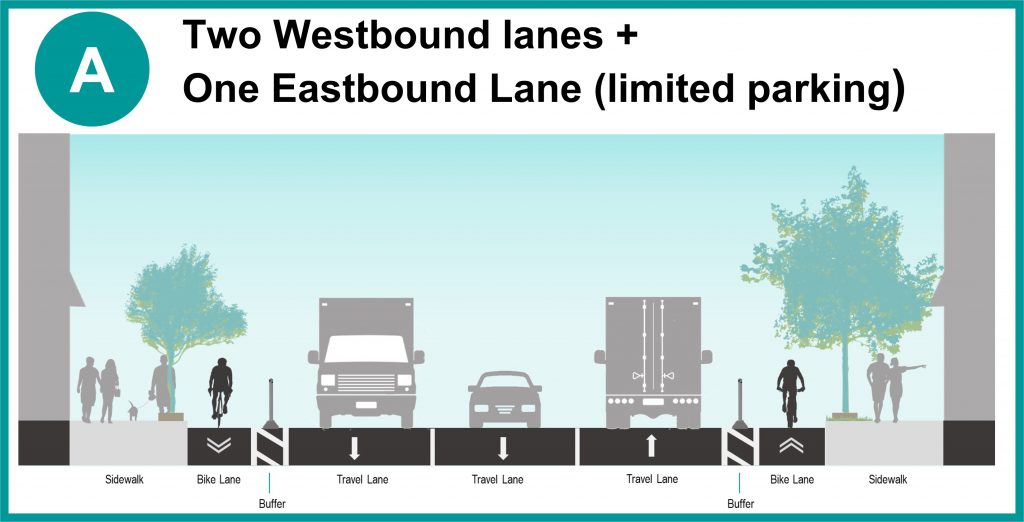
eglintonTOday Complete Street Project

From link.

Cross-section for Keele Street and Caledonia Road.
8b8b-eglintontoday-cross-section-A-keele-caledonia-1024x522.jpg


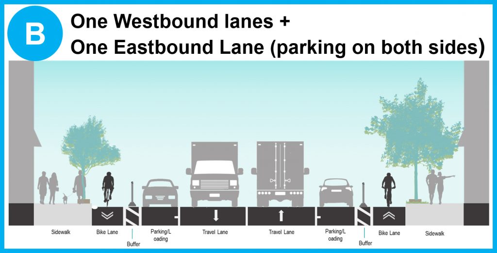
Cross-section for Caledonia Road and Oakwood Avenue.
8bcf-eglintontoday-cross-section-B-caledonia-oakwood-1024x522.jpg


Cross-sections for Oakwood Avenue and Bathurst Street.
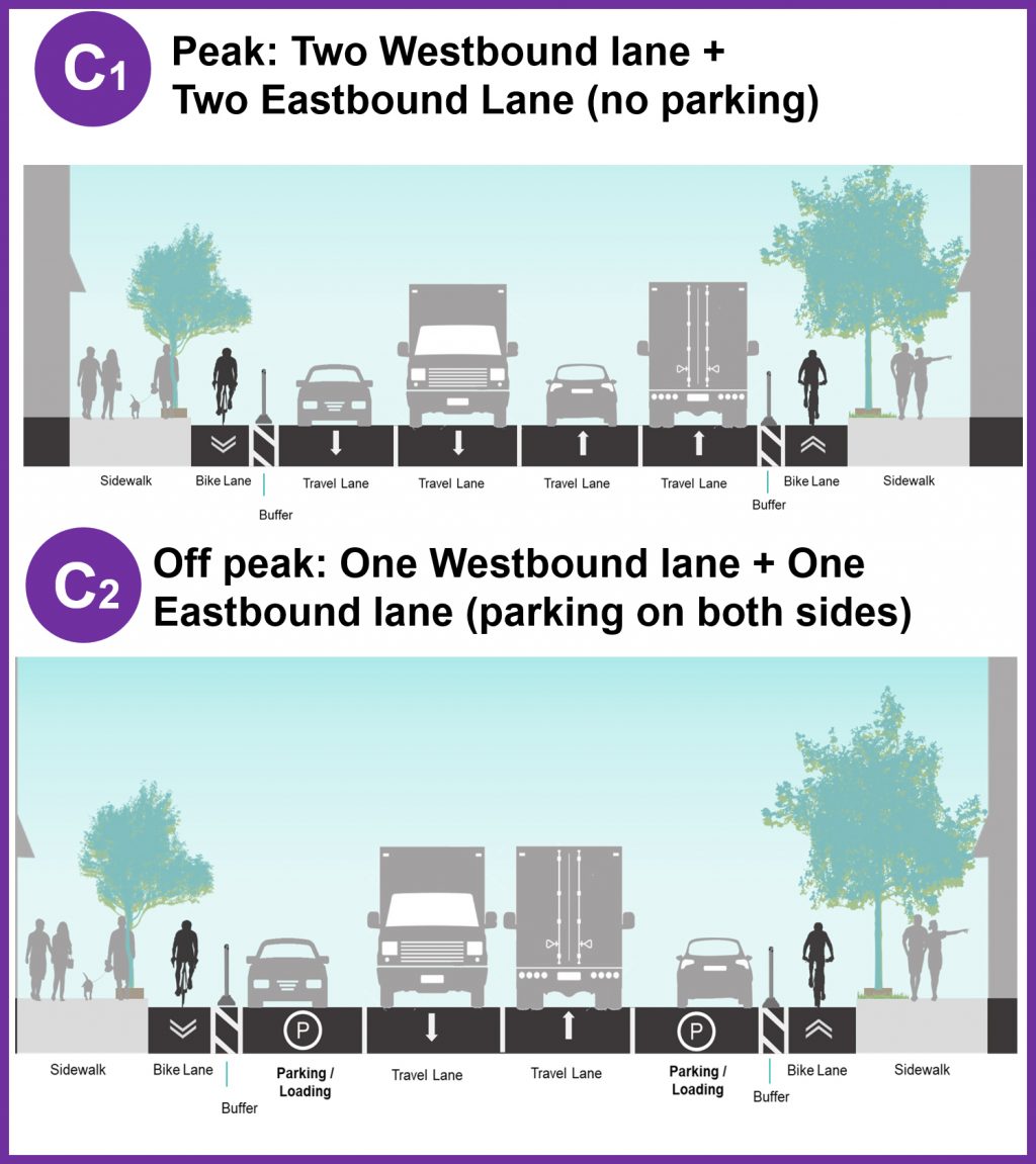
8b56-eglintontoday-cross-section-C-oakwood-bathurst-1024x1151.jpg


Cross-section Bathurst Street and Mount Pleasant Road.
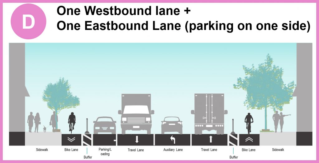
8b76-eglintontoday-cross-section-D-bathurst-mtpleasant-1024x522.jpg


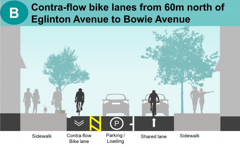
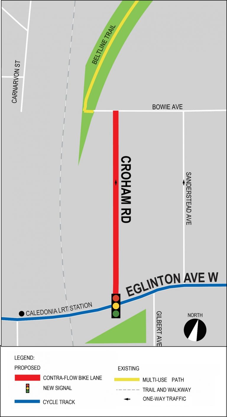
Cross-sections for Crowham Road between Eglinton Avenue to Bowie Avenue.
8bff-eglintontoday-local-street-croham-B-60m-north-bowie-768x469.jpg

92bc-eglintontoday-local-street-croham-map-768x1410.jpg


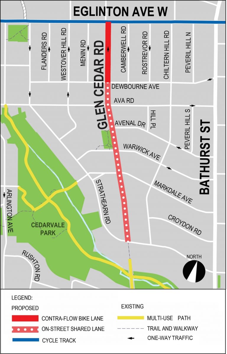
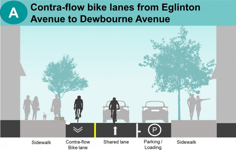
Cross-sections for Glen Cedar Road between Eglinton Avenue and Strathearn Road.
932c-eglintontoday-local-street-glen-cedar-map-768x1197.jpg

9301-eglintontoday-local-street-glen-cedar-A-eglinton-dewbourne-768x488.jpg


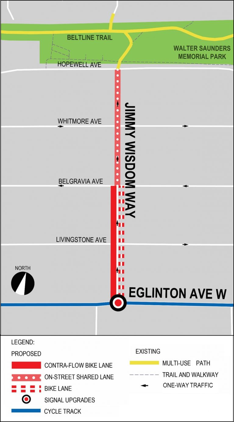
9375-eglintontoday-local-street-jimmy-wisdom-map-768x1385.jpg

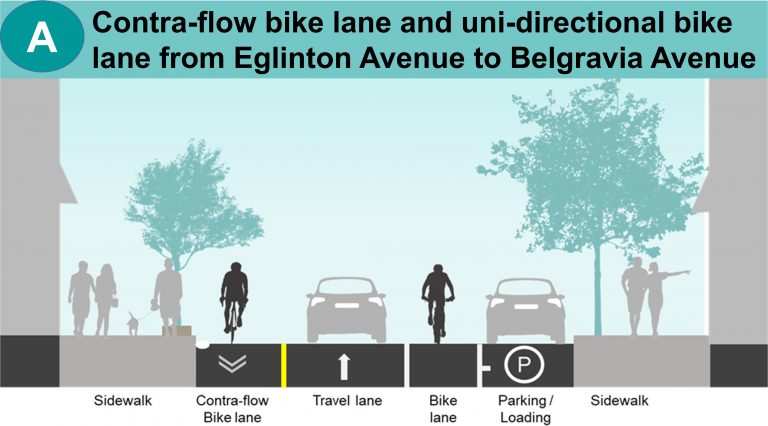
936c-eglintontoday-local-street-jimmy-wisdom-A-eglinton-belgravia-768x426.jpg


These HOV lanes will be moved to some other street that needs them...
1676087581951.png


Google Street View on eastbound Eglinton Avenue West just east of Caledonia.
 
Last edited:

Back
Top